You are here: Home > Network List > C - Chilean National Seismic Network Stations List
> Station GO09 Cerro Castillo, Chile > Earthquake Result Viewer
GO09 Cerro Castillo, Chile - Earthquake Result Viewer
| Earthquake location: |
Tonga Islands |
| Earthquake latitude/longitude: |
-15.6/-174.6 |
| Earthquake time(UTC): |
2023/05/10 (130) 16:02:00 GMT |
| Earthquake Depth: |
210 km |
| Earthquake Magnitude: |
7.6 mww |
| Earthquake Catalog/Contributor: |
NEIC PDE/us |
|
| Network: |
C Chilean National Seismic Network |
| Station: |
GO09 Cerro Castillo, Chile |
| Lat/Lon: |
51.27 S/72.34 W |
| Elevation: |
372 m |
|
| Distance: |
85.5 deg |
| Az: |
141.991 deg |
| Baz: |
250.837 deg |
| Ray Param: |
0.04426231 |
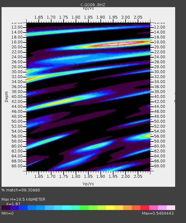
| Estimated Moho Depth: |
18.5 km |
| Estimated Crust Vp/Vs: |
1.97 |
| Assumed Crust Vp: |
6.438 km/s |
| Estimated Crust Vs: |
3.268 km/s |
| Estimated Crust Poisson's Ratio: |
0.33 |
|
| Radial Match: |
86.30668 % |
| Radial Bump: |
400 |
| Transverse Match: |
77.642456 % |
| Transverse Bump: |
400 |
| SOD ConfigId: |
30536071 |
| Insert Time: |
2023-05-24 16:14:43.639 +0000 |
| GWidth: |
2.5 |
| Max Bumps: |
400 |
| Tol: |
0.001 |
|

Signal To Noise
| Channel | StoN | STA | LTA |
| C:GO09: :BHZ:20230510T16:13:43.073986Z | 1.1329463 | 5.246498E-6 | 4.6308446E-6 |
| C:GO09: :BHN:20230510T16:13:43.073986Z | 1.5266621 | 1.1941754E-6 | 7.822133E-7 |
| C:GO09: :BHE:20230510T16:13:43.073986Z | 0.79518723 | 8.278339E-7 | 1.0410553E-6 |
| Arrivals |
| Ps | 2.8 SECOND |
| PpPs | 8.4 SECOND |
| PsPs/PpSs | 11 SECOND |


