You are here: Home > Network List > CC - Cascade Chain Volcano Monitoring Stations List
> Station GTWY Gateway Entrance Station > Earthquake Result Viewer
GTWY Gateway Entrance Station - Earthquake Result Viewer
| Earthquake location: |
Tonga Islands |
| Earthquake latitude/longitude: |
-15.6/-174.6 |
| Earthquake time(UTC): |
2023/05/10 (130) 16:02:00 GMT |
| Earthquake Depth: |
210 km |
| Earthquake Magnitude: |
7.6 mww |
| Earthquake Catalog/Contributor: |
NEIC PDE/us |
|
| Network: |
CC Cascade Chain Volcano Monitoring |
| Station: |
GTWY Gateway Entrance Station |
| Lat/Lon: |
46.74 N/121.92 W |
| Elevation: |
617 m |
|
| Distance: |
78.0 deg |
| Az: |
34.001 deg |
| Baz: |
231.585 deg |
| Ray Param: |
0.049395762 |
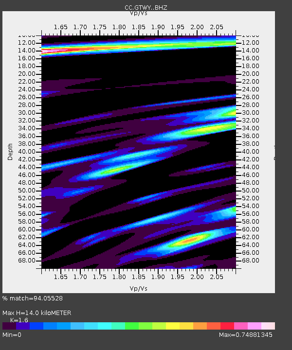
| Estimated Moho Depth: |
14.0 km |
| Estimated Crust Vp/Vs: |
1.60 |
| Assumed Crust Vp: |
6.597 km/s |
| Estimated Crust Vs: |
4.123 km/s |
| Estimated Crust Poisson's Ratio: |
0.18 |
|
| Radial Match: |
94.05528 % |
| Radial Bump: |
400 |
| Transverse Match: |
66.322876 % |
| Transverse Bump: |
400 |
| SOD ConfigId: |
30536071 |
| Insert Time: |
2023-05-24 16:15:38.499 +0000 |
| GWidth: |
2.5 |
| Max Bumps: |
400 |
| Tol: |
0.001 |
|

Signal To Noise
| Channel | StoN | STA | LTA |
| CC:GTWY: :BHZ:20230510T16:13:04.419994Z | 55.2723 | 6.2559907E-6 | 1.1318492E-7 |
| CC:GTWY: :BHN:20230510T16:13:04.419994Z | 5.8241444 | 1.1882294E-6 | 2.0401784E-7 |
| CC:GTWY: :BHE:20230510T16:13:04.419994Z | 7.040784 | 1.6491796E-6 | 2.3423239E-7 |
| Arrivals |
| Ps | 1.3 SECOND |
| PpPs | 5.3 SECOND |
| PsPs/PpSs | 6.6 SECOND |


