You are here: Home > Network List > CC - Cascade Chain Volcano Monitoring Stations List
> Station NORM North Rim, Newberry Volcano > Earthquake Result Viewer
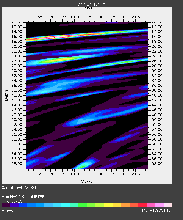
NORM North Rim, Newberry Volcano - Earthquake Result Viewer
| Earthquake location: |
Tonga Islands |
| Earthquake latitude/longitude: |
-15.6/-174.6 |
| Earthquake time(UTC): |
2023/05/10 (130) 16:02:00 GMT |
| Earthquake Depth: |
210 km |
| Earthquake Magnitude: |
7.6 mww |
| Earthquake Catalog/Contributor: |
NEIC PDE/us |
|
| Network: |
CC Cascade Chain Volcano Monitoring |
| Station: |
NORM North Rim, Newberry Volcano |
| Lat/Lon: |
43.74 N/121.25 W |
| Elevation: |
1286 m |
|
| Distance: |
76.5 deg |
| Az: |
36.725 deg |
| Baz: |
232.655 deg |
| Ray Param: |
0.050381508 |
| Estimated Moho Depth: |
16.0 km |
| Estimated Crust Vp/Vs: |
1.72 |
| Assumed Crust Vp: |
6.597 km/s |
| Estimated Crust Vs: |
3.847 km/s |
| Estimated Crust Poisson's Ratio: |
0.24 |
|
| Radial Match: |
92.60811 % |
| Radial Bump: |
400 |
| Transverse Match: |
79.946205 % |
| Transverse Bump: |
400 |
| SOD ConfigId: |
30536071 |
| Insert Time: |
2023-05-24 16:15:56.009 +0000 |
| GWidth: |
2.5 |
| Max Bumps: |
400 |
| Tol: |
0.001 |
|

Signal To Noise
| Channel | StoN | STA | LTA |
| CC:NORM: :BHZ:20230510T16:12:56.279979Z | 26.93954 | 4.5635843E-6 | 1.6940096E-7 |
| CC:NORM: :BHN:20230510T16:12:56.279979Z | 8.003345 | 1.8195118E-6 | 2.2734395E-7 |
| CC:NORM: :BHE:20230510T16:12:56.279979Z | 10.273768 | 3.2348073E-6 | 3.1486087E-7 |
| Arrivals |
| Ps | 1.8 SECOND |
| PpPs | 6.4 SECOND |
| PsPs/PpSs | 8.2 SECOND |


