You are here: Home > Network List > CI - Caltech Regional Seismic Network Stations List
> Station GLA Glamis, Glamis, CA, USA > Earthquake Result Viewer
GLA Glamis, Glamis, CA, USA - Earthquake Result Viewer
| Earthquake location: |
Tonga Islands |
| Earthquake latitude/longitude: |
-15.6/-174.6 |
| Earthquake time(UTC): |
2023/05/10 (130) 16:02:00 GMT |
| Earthquake Depth: |
210 km |
| Earthquake Magnitude: |
7.6 mww |
| Earthquake Catalog/Contributor: |
NEIC PDE/us |
|
| Network: |
CI Caltech Regional Seismic Network |
| Station: |
GLA Glamis, Glamis, CA, USA |
| Lat/Lon: |
33.05 N/114.83 W |
| Elevation: |
610 m |
|
| Distance: |
74.8 deg |
| Az: |
48.768 deg |
| Baz: |
239.641 deg |
| Ray Param: |
0.05154739 |
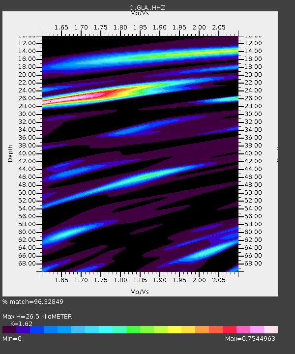
| Estimated Moho Depth: |
26.5 km |
| Estimated Crust Vp/Vs: |
1.62 |
| Assumed Crust Vp: |
6.155 km/s |
| Estimated Crust Vs: |
3.799 km/s |
| Estimated Crust Poisson's Ratio: |
0.19 |
|
| Radial Match: |
96.32849 % |
| Radial Bump: |
400 |
| Transverse Match: |
82.38558 % |
| Transverse Bump: |
400 |
| SOD ConfigId: |
30536071 |
| Insert Time: |
2023-05-24 16:17:32.983 +0000 |
| GWidth: |
2.5 |
| Max Bumps: |
400 |
| Tol: |
0.001 |
|

Signal To Noise
| Channel | StoN | STA | LTA |
| CI:GLA: :HHZ:20230510T16:12:46.422985Z | 19.704422 | 3.8250682E-6 | 1.9412234E-7 |
| CI:GLA: :HHN:20230510T16:12:46.422985Z | 12.004453 | 1.1713522E-6 | 9.757648E-8 |
| CI:GLA: :HHE:20230510T16:12:46.422985Z | 8.028107 | 1.818172E-6 | 2.2647582E-7 |
| Arrivals |
| Ps | 2.8 SECOND |
| PpPs | 11 SECOND |
| PsPs/PpSs | 14 SECOND |


