You are here: Home > Network List > CI - Caltech Regional Seismic Network Stations List
> Station LRL Laurel Mtn Radio Fac, Ridgecrest, CA, USA > Earthquake Result Viewer
LRL Laurel Mtn Radio Fac, Ridgecrest, CA, USA - Earthquake Result Viewer

| Earthquake location: |
Tonga Islands |
| Earthquake latitude/longitude: |
-15.6/-174.6 |
| Earthquake time(UTC): |
2023/05/10 (130) 16:02:00 GMT |
| Earthquake Depth: |
210 km |
| Earthquake Magnitude: |
7.6 mww |
| Earthquake Catalog/Contributor: |
NEIC PDE/us |
|
| Network: |
CI Caltech Regional Seismic Network |
| Station: |
LRL Laurel Mtn Radio Fac, Ridgecrest, CA, USA |
| Lat/Lon: |
35.48 N/117.68 W |
| Elevation: |
1340 m |
|
| Distance: |
74.1 deg |
| Az: |
45.34 deg |
| Baz: |
237.12 deg |
| Ray Param: |
0.052028067 |
| Estimated Moho Depth: |
26.75 km |
| Estimated Crust Vp/Vs: |
1.80 |
| Assumed Crust Vp: |
6.276 km/s |
| Estimated Crust Vs: |
3.496 km/s |
| Estimated Crust Poisson's Ratio: |
0.27 |
|
| Radial Match: |
97.55797 % |
| Radial Bump: |
400 |
| Transverse Match: |
83.59865 % |
| Transverse Bump: |
400 |
| SOD ConfigId: |
30536071 |
| Insert Time: |
2023-05-24 16:17:52.979 +0000 |
| GWidth: |
2.5 |
| Max Bumps: |
400 |
| Tol: |
0.001 |
|
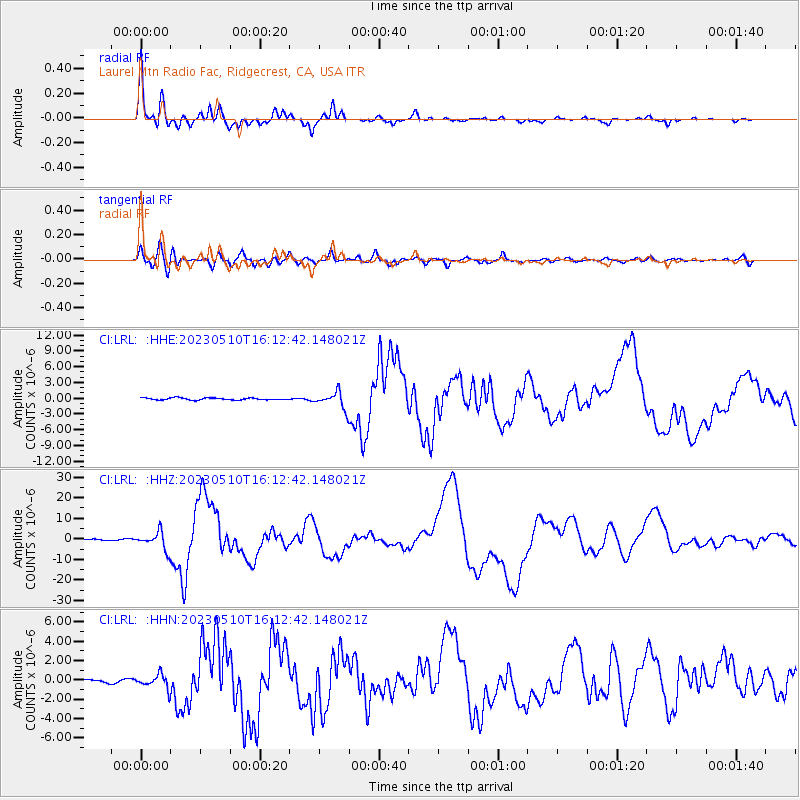
Signal To Noise
| Channel | StoN | STA | LTA |
| CI:LRL: :HHZ:20230510T16:12:42.148021Z | 19.09902 | 4.275186E-6 | 2.238432E-7 |
| CI:LRL: :HHN:20230510T16:12:42.148021Z | 2.5461037 | 7.0578017E-7 | 2.772001E-7 |
| CI:LRL: :HHE:20230510T16:12:42.148021Z | 8.271094 | 1.5955716E-6 | 1.9290938E-7 |
| Arrivals |
| Ps | 3.5 SECOND |
| PpPs | 12 SECOND |
| PsPs/PpSs | 15 SECOND |


