You are here: Home > Network List > CI - Caltech Regional Seismic Network Stations List
> Station MUR Murrieta > Earthquake Result Viewer
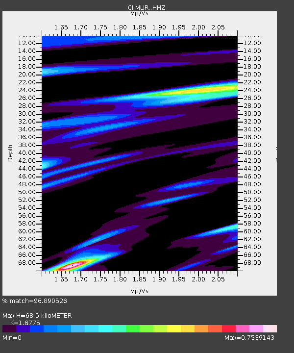
MUR Murrieta - Earthquake Result Viewer
| Earthquake location: |
Tonga Islands |
| Earthquake latitude/longitude: |
-15.6/-174.6 |
| Earthquake time(UTC): |
2023/05/10 (130) 16:02:00 GMT |
| Earthquake Depth: |
210 km |
| Earthquake Magnitude: |
7.6 mww |
| Earthquake Catalog/Contributor: |
NEIC PDE/us |
|
| Network: |
CI Caltech Regional Seismic Network |
| Station: |
MUR Murrieta |
| Lat/Lon: |
33.60 N/117.20 W |
| Elevation: |
562 m |
|
| Distance: |
73.4 deg |
| Az: |
47.212 deg |
| Baz: |
237.92 deg |
| Ray Param: |
0.052482992 |
| Estimated Moho Depth: |
68.5 km |
| Estimated Crust Vp/Vs: |
1.68 |
| Assumed Crust Vp: |
6.264 km/s |
| Estimated Crust Vs: |
3.734 km/s |
| Estimated Crust Poisson's Ratio: |
0.22 |
|
| Radial Match: |
96.890526 % |
| Radial Bump: |
345 |
| Transverse Match: |
80.62222 % |
| Transverse Bump: |
400 |
| SOD ConfigId: |
30536071 |
| Insert Time: |
2023-05-24 16:18:01.691 +0000 |
| GWidth: |
2.5 |
| Max Bumps: |
400 |
| Tol: |
0.001 |
|

Signal To Noise
| Channel | StoN | STA | LTA |
| CI:MUR: :HHZ:20230510T16:12:38.279979Z | 12.848617 | 4.974666E-6 | 3.8717522E-7 |
| CI:MUR: :HHN:20230510T16:12:38.279979Z | 5.0785575 | 1.456244E-6 | 2.8674364E-7 |
| CI:MUR: :HHE:20230510T16:12:38.279979Z | 4.0362167 | 1.4993273E-6 | 3.7146847E-7 |
| Arrivals |
| Ps | 7.7 SECOND |
| PpPs | 28 SECOND |
| PsPs/PpSs | 36 SECOND |


