You are here: Home > Network List > CN - Canadian National Seismograph Network Stations List
> Station PACB Port Alice, BC, CA > Earthquake Result Viewer
PACB Port Alice, BC, CA - Earthquake Result Viewer
| Earthquake location: |
Tonga Islands |
| Earthquake latitude/longitude: |
-15.6/-174.6 |
| Earthquake time(UTC): |
2023/05/10 (130) 16:02:00 GMT |
| Earthquake Depth: |
210 km |
| Earthquake Magnitude: |
7.6 mww |
| Earthquake Catalog/Contributor: |
NEIC PDE/us |
|
| Network: |
CN Canadian National Seismograph Network |
| Station: |
PACB Port Alice, BC, CA |
| Lat/Lon: |
50.44 N/127.49 W |
| Elevation: |
24 m |
|
| Distance: |
77.6 deg |
| Az: |
28.664 deg |
| Baz: |
226.286 deg |
| Ray Param: |
0.04963991 |
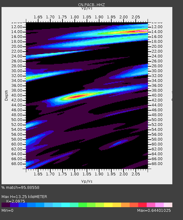
| Estimated Moho Depth: |
13.25 km |
| Estimated Crust Vp/Vs: |
2.10 |
| Assumed Crust Vp: |
6.545 km/s |
| Estimated Crust Vs: |
3.121 km/s |
| Estimated Crust Poisson's Ratio: |
0.35 |
|
| Radial Match: |
95.88558 % |
| Radial Bump: |
369 |
| Transverse Match: |
86.897835 % |
| Transverse Bump: |
400 |
| SOD ConfigId: |
30536071 |
| Insert Time: |
2023-05-24 16:20:07.909 +0000 |
| GWidth: |
2.5 |
| Max Bumps: |
400 |
| Tol: |
0.001 |
|

Signal To Noise
| Channel | StoN | STA | LTA |
| CN:PACB: :HHZ:20230510T16:13:02.419994Z | 31.66287 | 6.993648E-6 | 2.2087853E-7 |
| CN:PACB: :HHN:20230510T16:13:02.419994Z | 14.380331 | 2.5128213E-6 | 1.7474015E-7 |
| CN:PACB: :HHE:20230510T16:13:02.419994Z | 8.105315 | 1.2196429E-6 | 1.5047445E-7 |
| Arrivals |
| Ps | 2.3 SECOND |
| PpPs | 6.1 SECOND |
| PsPs/PpSs | 8.4 SECOND |


