You are here: Home > Network List > GS - US Geological Survey Networks Stations List
> Station ASA5 ASA5 > Earthquake Result Viewer
ASA5 ASA5 - Earthquake Result Viewer
| Earthquake location: |
Tonga Islands |
| Earthquake latitude/longitude: |
-15.6/-174.6 |
| Earthquake time(UTC): |
2023/05/10 (130) 16:02:00 GMT |
| Earthquake Depth: |
210 km |
| Earthquake Magnitude: |
7.6 mww |
| Earthquake Catalog/Contributor: |
NEIC PDE/us |
|
| Network: |
GS US Geological Survey Networks |
| Station: |
ASA5 ASA5 |
| Lat/Lon: |
34.94 N/106.46 W |
| Elevation: |
1835 m |
|
| Distance: |
81.8 deg |
| Az: |
50.383 deg |
| Baz: |
244.633 deg |
| Ray Param: |
0.046802647 |
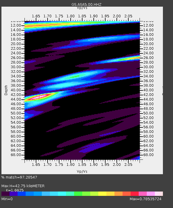
| Estimated Moho Depth: |
42.75 km |
| Estimated Crust Vp/Vs: |
1.66 |
| Assumed Crust Vp: |
6.502 km/s |
| Estimated Crust Vs: |
3.911 km/s |
| Estimated Crust Poisson's Ratio: |
0.22 |
|
| Radial Match: |
97.28547 % |
| Radial Bump: |
348 |
| Transverse Match: |
93.7626 % |
| Transverse Bump: |
400 |
| SOD ConfigId: |
30536071 |
| Insert Time: |
2023-05-24 16:22:19.742 +0000 |
| GWidth: |
2.5 |
| Max Bumps: |
400 |
| Tol: |
0.001 |
|

Signal To Noise
| Channel | StoN | STA | LTA |
| GS:ASA5:00:HHZ:20230510T16:13:24.729992Z | 22.918291 | 3.419794E-6 | 1.492168E-7 |
| GS:ASA5:00:HH1:20230510T16:13:24.729992Z | 5.5514116 | 6.369667E-7 | 1.1473959E-7 |
| GS:ASA5:00:HH2:20230510T16:13:24.729992Z | 5.4564004 | 7.9506594E-7 | 1.4571255E-7 |
| Arrivals |
| Ps | 4.5 SECOND |
| PpPs | 17 SECOND |
| PsPs/PpSs | 21 SECOND |


