You are here: Home > Network List > GS - US Geological Survey Networks Stations List
> Station ASL8 Albuquerque, New Mexico, USA > Earthquake Result Viewer
ASL8 Albuquerque, New Mexico, USA - Earthquake Result Viewer

| Earthquake location: |
Tonga Islands |
| Earthquake latitude/longitude: |
-15.6/-174.6 |
| Earthquake time(UTC): |
2023/05/10 (130) 16:02:00 GMT |
| Earthquake Depth: |
210 km |
| Earthquake Magnitude: |
7.6 mww |
| Earthquake Catalog/Contributor: |
NEIC PDE/us |
|
| Network: |
GS US Geological Survey Networks |
| Station: |
ASL8 Albuquerque, New Mexico, USA |
| Lat/Lon: |
34.95 N/106.46 W |
| Elevation: |
1820 m |
|
| Distance: |
81.8 deg |
| Az: |
50.382 deg |
| Baz: |
244.634 deg |
| Ray Param: |
0.04680073 |
| Estimated Moho Depth: |
42.25 km |
| Estimated Crust Vp/Vs: |
1.68 |
| Assumed Crust Vp: |
6.502 km/s |
| Estimated Crust Vs: |
3.87 km/s |
| Estimated Crust Poisson's Ratio: |
0.23 |
|
| Radial Match: |
97.62708 % |
| Radial Bump: |
389 |
| Transverse Match: |
94.212456 % |
| Transverse Bump: |
400 |
| SOD ConfigId: |
30536071 |
| Insert Time: |
2023-05-24 16:22:22.900 +0000 |
| GWidth: |
2.5 |
| Max Bumps: |
400 |
| Tol: |
0.001 |
|
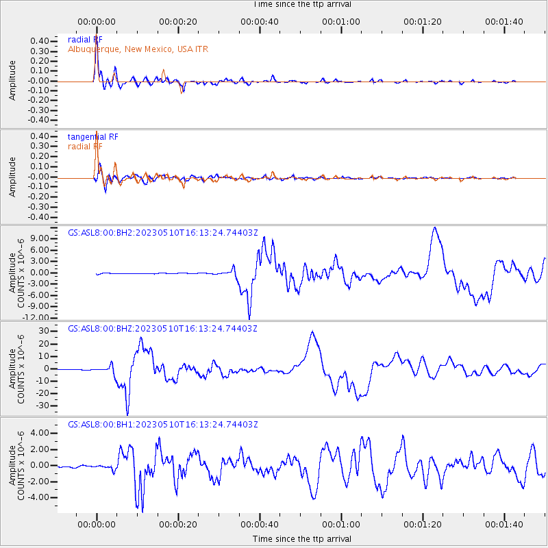
Signal To Noise
| Channel | StoN | STA | LTA |
| GS:ASL8:00:BHZ:20230510T16:13:24.74403Z | 20.142172 | 3.3803135E-6 | 1.678227E-7 |
| GS:ASL8:00:BH1:20230510T16:13:24.74403Z | 2.0014327 | 2.9736722E-7 | 1.4857719E-7 |
| GS:ASL8:00:BH2:20230510T16:13:24.74403Z | 8.921916 | 9.723842E-7 | 1.0898827E-7 |
| Arrivals |
| Ps | 4.5 SECOND |
| PpPs | 17 SECOND |
| PsPs/PpSs | 21 SECOND |


