You are here: Home > Network List > UU - University of Utah Regional Network Stations List
> Station FORU South Mineral Mountains, UT, USA > Earthquake Result Viewer
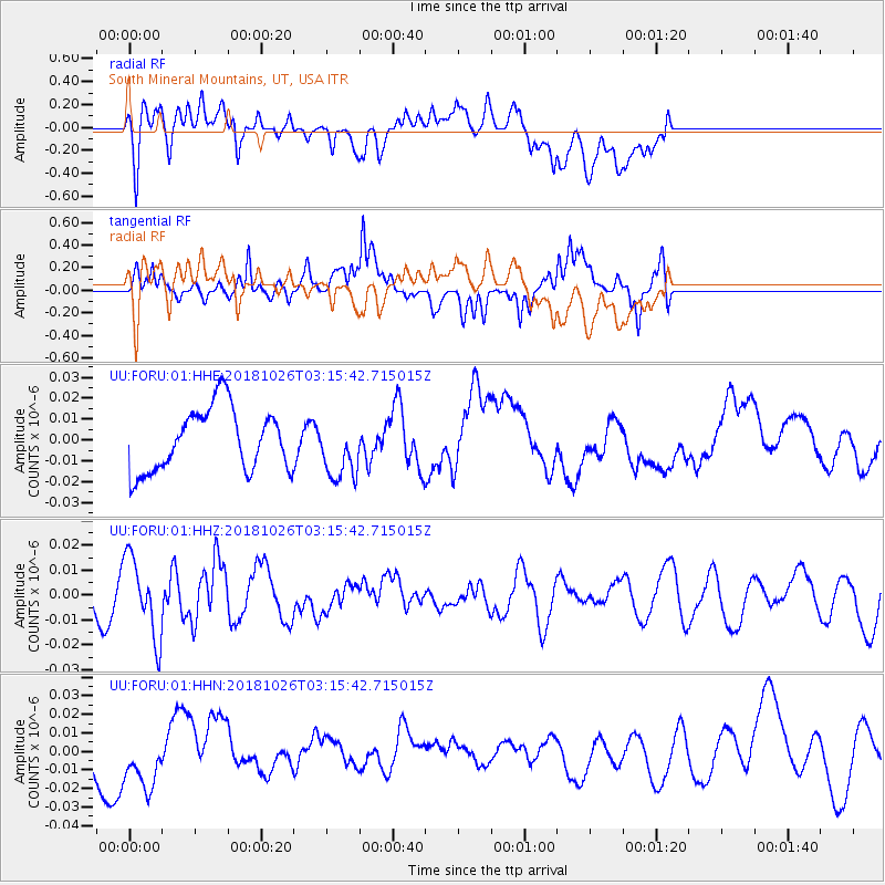
FORU South Mineral Mountains, UT, USA - Earthquake Result Viewer
*The percent match for this event was below the threshold and hence no stack was calculated.
| Earthquake location: |
Hokkaido, Japan Region |
| Earthquake latitude/longitude: |
44.5/145.4 |
| Earthquake time(UTC): |
2018/10/26 (299) 03:04:53 GMT |
| Earthquake Depth: |
10 km |
| Earthquake Magnitude: |
5.6 Mww |
| Earthquake Catalog/Contributor: |
NEIC PDE/us |
|
| Network: |
UU University of Utah Regional Network |
| Station: |
FORU South Mineral Mountains, UT, USA |
| Lat/Lon: |
38.46 N/112.86 W |
| Elevation: |
1840 m |
|
| Distance: |
71.4 deg |
| Az: |
54.19 deg |
| Baz: |
312.378 deg |
| Ray Param: |
$rayparam |
*The percent match for this event was below the threshold and hence was not used in the summary stack. |
|
| Radial Match: |
54.275265 % |
| Radial Bump: |
400 |
| Transverse Match: |
43.672752 % |
| Transverse Bump: |
322 |
| SOD ConfigId: |
3103472 |
| Insert Time: |
2018-11-09 17:07:04.034 +0000 |
| GWidth: |
2.5 |
| Max Bumps: |
400 |
| Tol: |
0.001 |
|
Signal To Noise
| Channel | StoN | STA | LTA |
| UU:FORU:01:HHZ:20181026T03:15:42.715015Z | 1.5294932 | 1.5850526E-8 | 1.0363254E-8 |
| UU:FORU:01:HHN:20181026T03:15:42.715015Z | 1.3647145 | 1.9095864E-8 | 1.399257E-8 |
| UU:FORU:01:HHE:20181026T03:15:42.715015Z | 0.97179294 | 1.46417E-8 | 1.5066687E-8 |
| Arrivals |
| Ps | |
| PpPs | |
| PsPs/PpSs | |


