You are here: Home > Network List > GS - US Geological Survey Networks Stations List
> Station OK051 E0350 and S34600 roads, Ralston OK > Earthquake Result Viewer
OK051 E0350 and S34600 roads, Ralston OK - Earthquake Result Viewer
| Earthquake location: |
Tonga Islands |
| Earthquake latitude/longitude: |
-15.6/-174.6 |
| Earthquake time(UTC): |
2023/05/10 (130) 16:02:00 GMT |
| Earthquake Depth: |
210 km |
| Earthquake Magnitude: |
7.6 mww |
| Earthquake Catalog/Contributor: |
NEIC PDE/us |
|
| Network: |
GS US Geological Survey Networks |
| Station: |
OK051 E0350 and S34600 roads, Ralston OK |
| Lat/Lon: |
36.50 N/96.84 W |
| Elevation: |
263 m |
|
| Distance: |
89.6 deg |
| Az: |
51.948 deg |
| Baz: |
250.353 deg |
| Ray Param: |
0.04171239 |
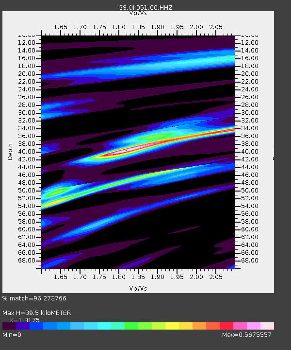
| Estimated Moho Depth: |
39.5 km |
| Estimated Crust Vp/Vs: |
1.82 |
| Assumed Crust Vp: |
6.483 km/s |
| Estimated Crust Vs: |
3.567 km/s |
| Estimated Crust Poisson's Ratio: |
0.28 |
|
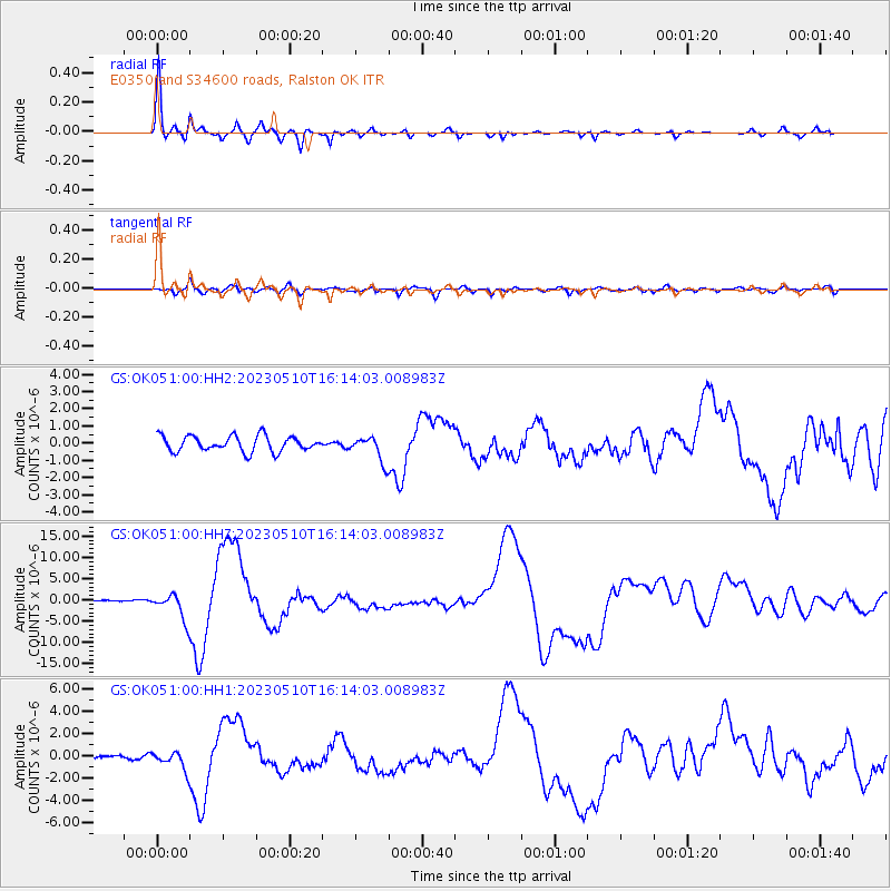
| Radial Match: |
96.273766 % |
| Radial Bump: |
334 |
| Transverse Match: |
75.74234 % |
| Transverse Bump: |
400 |
| SOD ConfigId: |
30536071 |
| Insert Time: |
2023-05-24 16:22:35.398 +0000 |
| GWidth: |
2.5 |
| Max Bumps: |
400 |
| Tol: |
0.001 |
|
Signal To Noise
| Channel | StoN | STA | LTA |
| GS:OK051:00:HHZ:20230510T16:14:03.008983Z | 8.870881 | 3.0552424E-6 | 3.4441248E-7 |
| GS:OK051:00:HH1:20230510T16:14:03.008983Z | 1.7857035 | 7.9430595E-7 | 4.4481402E-7 |
| GS:OK051:00:HH2:20230510T16:14:03.008983Z | 1.6412176 | 7.358731E-7 | 4.483702E-7 |
| Arrivals |
| Ps | 5.1 SECOND |
| PpPs | 17 SECOND |
| PsPs/PpSs | 22 SECOND |


