You are here: Home > Network List > HV - Hawaiian Volcano Observatory Network Stations List
> Station AIND Ainapo Ranch, Hawaii Digital > Earthquake Result Viewer
AIND Ainapo Ranch, Hawaii Digital - Earthquake Result Viewer
| Earthquake location: |
Tonga Islands |
| Earthquake latitude/longitude: |
-15.6/-174.6 |
| Earthquake time(UTC): |
2023/05/10 (130) 16:02:00 GMT |
| Earthquake Depth: |
210 km |
| Earthquake Magnitude: |
7.6 mww |
| Earthquake Catalog/Contributor: |
NEIC PDE/us |
|
| Network: |
HV Hawaiian Volcano Observatory Network |
| Station: |
AIND Ainapo Ranch, Hawaii Digital |
| Lat/Lon: |
19.37 N/155.46 W |
| Elevation: |
1524 m |
|
| Distance: |
39.5 deg |
| Az: |
29.116 deg |
| Baz: |
209.779 deg |
| Ray Param: |
0.07412881 |
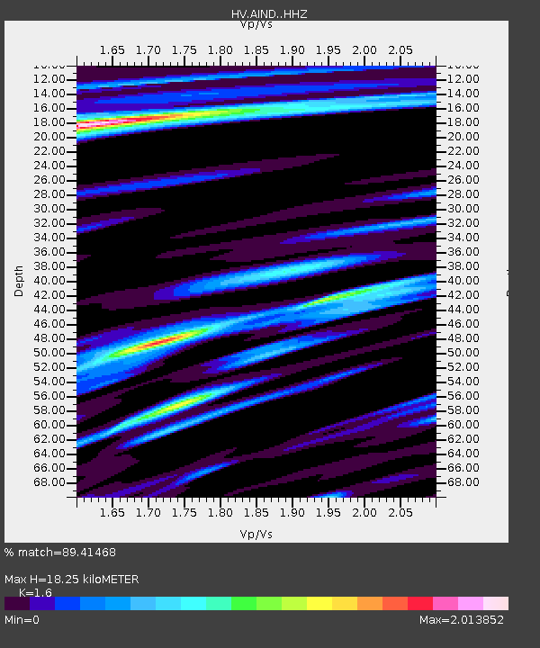
| Estimated Moho Depth: |
18.25 km |
| Estimated Crust Vp/Vs: |
1.60 |
| Assumed Crust Vp: |
5.195 km/s |
| Estimated Crust Vs: |
3.247 km/s |
| Estimated Crust Poisson's Ratio: |
0.18 |
|
| Radial Match: |
89.41468 % |
| Radial Bump: |
400 |
| Transverse Match: |
70.955025 % |
| Transverse Bump: |
400 |
| SOD ConfigId: |
30536071 |
| Insert Time: |
2023-05-24 16:22:45.865 +0000 |
| GWidth: |
2.5 |
| Max Bumps: |
400 |
| Tol: |
0.001 |
|

Signal To Noise
| Channel | StoN | STA | LTA |
| HV:AIND: :HHZ:20230510T16:08:40.289013Z | 3.2864063 | 8.447281E-6 | 2.5703703E-6 |
| HV:AIND: :HHN:20230510T16:08:40.289013Z | 3.3069484 | 9.149812E-6 | 2.7668445E-6 |
| HV:AIND: :HHE:20230510T16:08:40.289013Z | 1.3032055 | 4.275861E-6 | 3.281034E-6 |
| Arrivals |
| Ps | 2.2 SECOND |
| PpPs | 8.7 SECOND |
| PsPs/PpSs | 11 SECOND |


