You are here: Home > Network List > IU - Global Seismograph Network (GSN - IRIS/USGS) Stations List
> Station ULN Ulaanbaatar, Mongolia > Earthquake Result Viewer
ULN Ulaanbaatar, Mongolia - Earthquake Result Viewer
| Earthquake location: |
Tonga Islands |
| Earthquake latitude/longitude: |
-15.6/-174.6 |
| Earthquake time(UTC): |
2023/05/10 (130) 16:02:00 GMT |
| Earthquake Depth: |
210 km |
| Earthquake Magnitude: |
7.6 mww |
| Earthquake Catalog/Contributor: |
NEIC PDE/us |
|
| Network: |
IU Global Seismograph Network (GSN - IRIS/USGS) |
| Station: |
ULN Ulaanbaatar, Mongolia |
| Lat/Lon: |
47.87 N/107.05 E |
| Elevation: |
1610 m |
|
| Distance: |
93.8 deg |
| Az: |
318.63 deg |
| Baz: |
108.945 deg |
| Ray Param: |
0.04104175 |
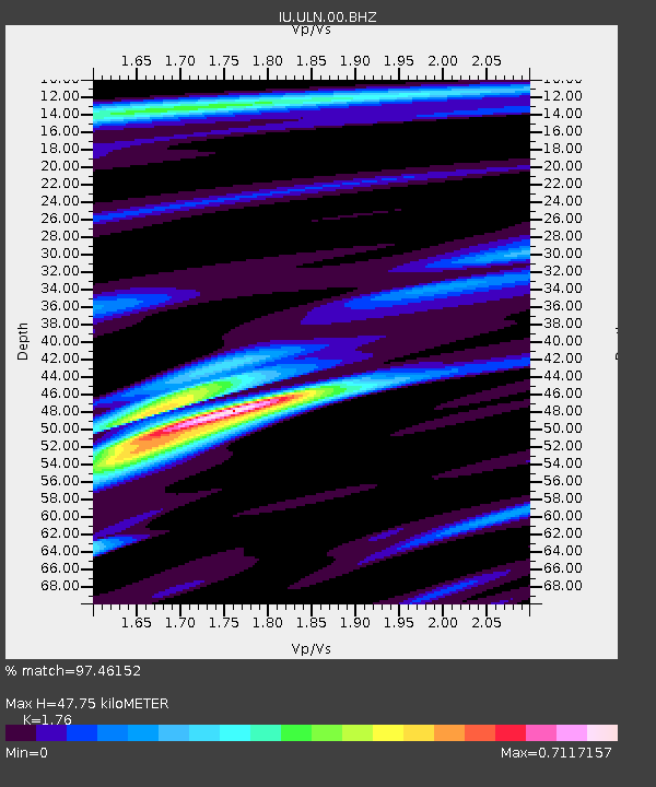
| Estimated Moho Depth: |
47.75 km |
| Estimated Crust Vp/Vs: |
1.76 |
| Assumed Crust Vp: |
6.642 km/s |
| Estimated Crust Vs: |
3.774 km/s |
| Estimated Crust Poisson's Ratio: |
0.26 |
|
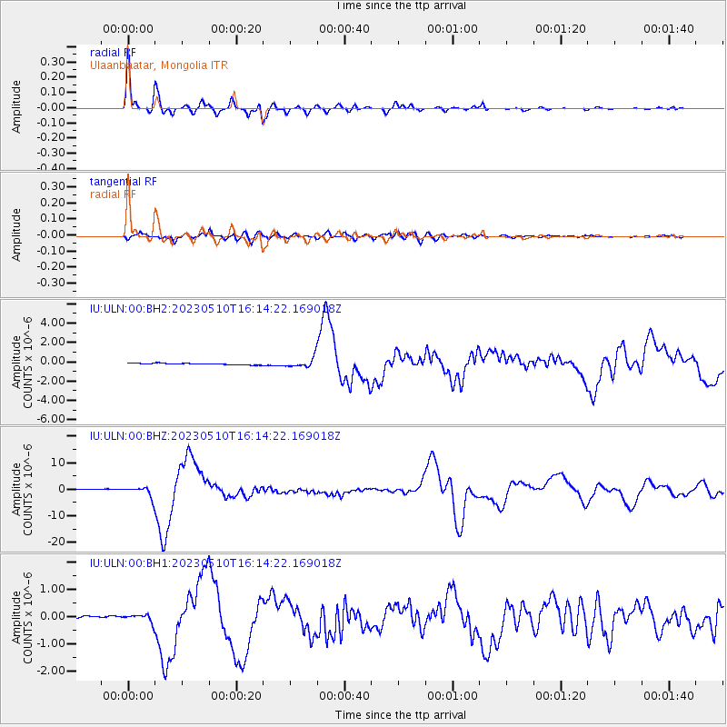
| Radial Match: |
97.46152 % |
| Radial Bump: |
313 |
| Transverse Match: |
92.40236 % |
| Transverse Bump: |
400 |
| SOD ConfigId: |
30536071 |
| Insert Time: |
2023-05-24 16:24:18.469 +0000 |
| GWidth: |
2.5 |
| Max Bumps: |
400 |
| Tol: |
0.001 |
|
Signal To Noise
| Channel | StoN | STA | LTA |
| IU:ULN:00:BHZ:20230510T16:14:22.169018Z | 11.741428 | 2.158506E-6 | 1.8383676E-7 |
| IU:ULN:00:BH1:20230510T16:14:22.169018Z | 4.3188066 | 1.5683634E-7 | 3.6314738E-8 |
| IU:ULN:00:BH2:20230510T16:14:22.169018Z | 6.4948773 | 4.9798484E-7 | 7.667347E-8 |
| Arrivals |
| Ps | 5.6 SECOND |
| PpPs | 19 SECOND |
| PsPs/PpSs | 25 SECOND |


