You are here: Home > Network List > IW - Intermountain West Stations List
> Station MFID Near Bowns Crk and Slater Flat Rd, Idaho, USA > Earthquake Result Viewer
MFID Near Bowns Crk and Slater Flat Rd, Idaho, USA - Earthquake Result Viewer
| Earthquake location: |
Tonga Islands |
| Earthquake latitude/longitude: |
-15.6/-174.6 |
| Earthquake time(UTC): |
2023/05/10 (130) 16:02:00 GMT |
| Earthquake Depth: |
210 km |
| Earthquake Magnitude: |
7.6 mww |
| Earthquake Catalog/Contributor: |
NEIC PDE/us |
|
| Network: |
IW Intermountain West |
| Station: |
MFID Near Bowns Crk and Slater Flat Rd, Idaho, USA |
| Lat/Lon: |
43.42 N/115.83 W |
| Elevation: |
1302 m |
|
| Distance: |
79.6 deg |
| Az: |
39.318 deg |
| Baz: |
236.92 deg |
| Ray Param: |
0.04834227 |
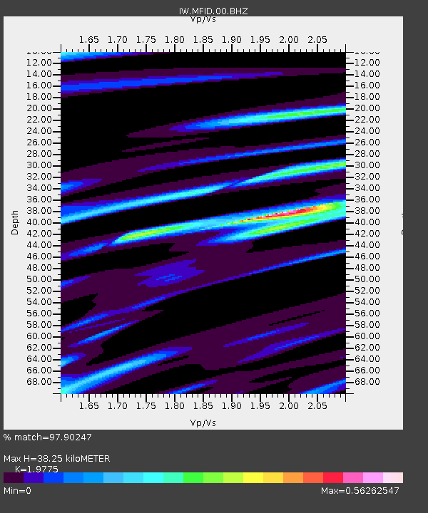
| Estimated Moho Depth: |
38.25 km |
| Estimated Crust Vp/Vs: |
1.98 |
| Assumed Crust Vp: |
6.291 km/s |
| Estimated Crust Vs: |
3.181 km/s |
| Estimated Crust Poisson's Ratio: |
0.33 |
|
| Radial Match: |
97.90247 % |
| Radial Bump: |
363 |
| Transverse Match: |
84.629745 % |
| Transverse Bump: |
400 |
| SOD ConfigId: |
30536071 |
| Insert Time: |
2023-05-24 16:24:26.478 +0000 |
| GWidth: |
2.5 |
| Max Bumps: |
400 |
| Tol: |
0.001 |
|

Signal To Noise
| Channel | StoN | STA | LTA |
| IW:MFID:00:BHZ:20230510T16:13:12.898998Z | 21.824091 | 5.3860067E-6 | 2.467918E-7 |
| IW:MFID:00:BH1:20230510T16:13:12.898998Z | 7.0657463 | 9.838802E-7 | 1.3924648E-7 |
| IW:MFID:00:BH2:20230510T16:13:12.898998Z | 9.065891 | 1.803162E-6 | 1.9889518E-7 |
| Arrivals |
| Ps | 6.1 SECOND |
| PpPs | 18 SECOND |
| PsPs/PpSs | 24 SECOND |


