You are here: Home > Network List > MI - USGS Northern Mariana Islands Network () Stations List
> Station DPS HUB > Earthquake Result Viewer
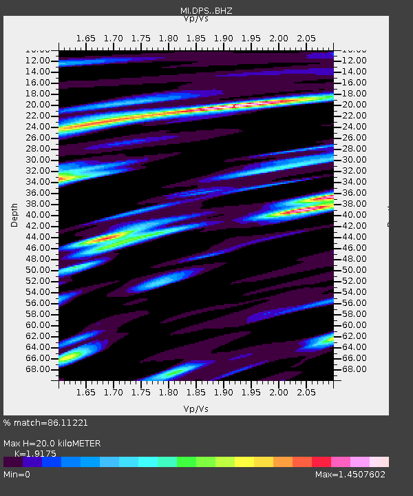
DPS HUB - Earthquake Result Viewer
| Earthquake location: |
Tonga Islands |
| Earthquake latitude/longitude: |
-15.6/-174.6 |
| Earthquake time(UTC): |
2023/05/10 (130) 16:02:00 GMT |
| Earthquake Depth: |
210 km |
| Earthquake Magnitude: |
7.6 mww |
| Earthquake Catalog/Contributor: |
NEIC PDE/us |
|
| Network: |
MI USGS Northern Mariana Islands Network () |
| Station: |
DPS HUB |
| Lat/Lon: |
15.24 N/145.79 E |
| Elevation: |
144 m |
|
| Distance: |
49.7 deg |
| Az: |
306.209 deg |
| Baz: |
126.342 deg |
| Ray Param: |
0.06775851 |
| Estimated Moho Depth: |
20.0 km |
| Estimated Crust Vp/Vs: |
1.92 |
| Assumed Crust Vp: |
4.24 km/s |
| Estimated Crust Vs: |
2.211 km/s |
| Estimated Crust Poisson's Ratio: |
0.31 |
|
| Radial Match: |
86.11221 % |
| Radial Bump: |
400 |
| Transverse Match: |
77.79695 % |
| Transverse Bump: |
400 |
| SOD ConfigId: |
30536071 |
| Insert Time: |
2023-05-24 16:25:13.959 +0000 |
| GWidth: |
2.5 |
| Max Bumps: |
400 |
| Tol: |
0.001 |
|

Signal To Noise
| Channel | StoN | STA | LTA |
| MI:DPS: :BHZ:20230510T16:10:00.35899Z | 15.572126 | 1.2868586E-5 | 8.263859E-7 |
| MI:DPS: :BHN:20230510T16:10:00.35899Z | 5.0260806 | 4.2124475E-6 | 8.381177E-7 |
| MI:DPS: :BHE:20230510T16:10:00.35899Z | 4.5079966 | 6.0332413E-6 | 1.338342E-6 |
| Arrivals |
| Ps | 4.4 SECOND |
| PpPs | 13 SECOND |
| PsPs/PpSs | 18 SECOND |


