You are here: Home > Network List > TA - USArray Transportable Network (new EarthScope stations) Stations List
> Station Q23A Hartsel, CO, USA > Earthquake Result Viewer
Q23A Hartsel, CO, USA - Earthquake Result Viewer
| Earthquake location: |
Near Coast Of Central Chile |
| Earthquake latitude/longitude: |
-36.2/-73.3 |
| Earthquake time(UTC): |
2010/03/16 (075) 02:21:57 GMT |
| Earthquake Depth: |
18 km |
| Earthquake Magnitude: |
6.0 MB, 6.7 MS, 6.7 MW, 6.6 MW |
| Earthquake Catalog/Contributor: |
WHDF/NEIC |
|
| Network: |
TA USArray Transportable Network (new EarthScope stations) |
| Station: |
Q23A Hartsel, CO, USA |
| Lat/Lon: |
38.90 N/105.83 W |
| Elevation: |
2774 m |
|
| Distance: |
80.6 deg |
| Az: |
334.795 deg |
| Baz: |
153.809 deg |
| Ray Param: |
0.04816877 |
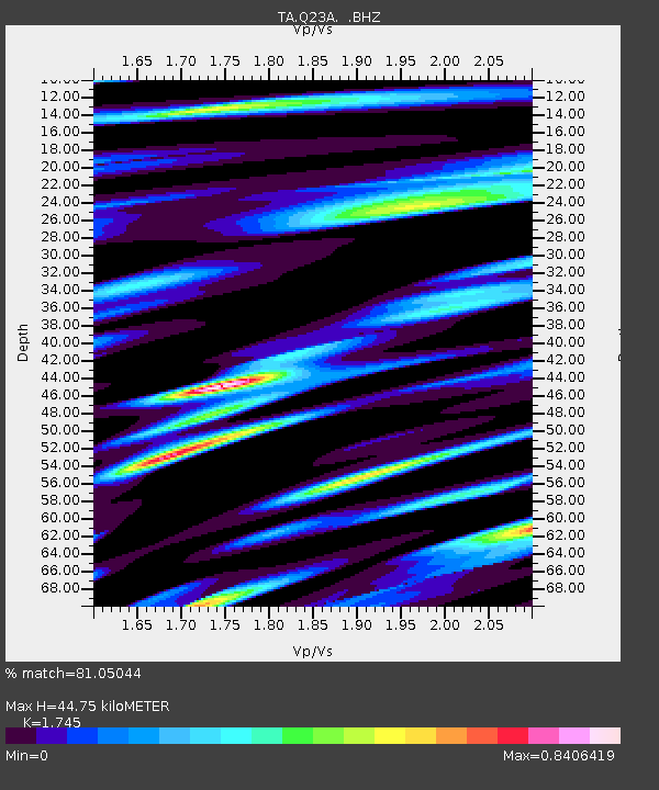
| Estimated Moho Depth: |
44.75 km |
| Estimated Crust Vp/Vs: |
1.75 |
| Assumed Crust Vp: |
6.159 km/s |
| Estimated Crust Vs: |
3.529 km/s |
| Estimated Crust Poisson's Ratio: |
0.26 |
|
| Radial Match: |
81.05044 % |
| Radial Bump: |
400 |
| Transverse Match: |
68.735985 % |
| Transverse Bump: |
400 |
| SOD ConfigId: |
308276 |
| Insert Time: |
2010-06-22 20:11:25.670 +0000 |
| GWidth: |
2.5 |
| Max Bumps: |
400 |
| Tol: |
0.001 |
|

Signal To Noise
| Channel | StoN | STA | LTA |
| TA:Q23A: :BHZ:20100316T02:33:37.799985Z | 3.5908785 | 8.4227156E-7 | 2.3455864E-7 |
| TA:Q23A: :BHN:20100316T02:33:37.799985Z | 1.0762068 | 3.6635268E-7 | 3.4041105E-7 |
| TA:Q23A: :BHE:20100316T02:33:37.799985Z | 1.0997471 | 4.550277E-7 | 4.1375668E-7 |
| Arrivals |
| Ps | 5.6 SECOND |
| PpPs | 19 SECOND |
| PsPs/PpSs | 25 SECOND |


