You are here: Home > Network List > TA - USArray Transportable Network (new EarthScope stations) Stations List
> Station K21A Alcova, Casper, WY, USA > Earthquake Result Viewer
K21A Alcova, Casper, WY, USA - Earthquake Result Viewer

| Earthquake location: |
Near Coast Of Central Chile |
| Earthquake latitude/longitude: |
-36.2/-73.3 |
| Earthquake time(UTC): |
2010/03/16 (075) 02:21:57 GMT |
| Earthquake Depth: |
18 km |
| Earthquake Magnitude: |
6.0 MB, 6.7 MS, 6.7 MW, 6.6 MW |
| Earthquake Catalog/Contributor: |
WHDF/NEIC |
|
| Network: |
TA USArray Transportable Network (new EarthScope stations) |
| Station: |
K21A Alcova, Casper, WY, USA |
| Lat/Lon: |
42.63 N/107.25 W |
| Elevation: |
1960 m |
|
| Distance: |
84.4 deg |
| Az: |
335.507 deg |
| Baz: |
152.979 deg |
| Ray Param: |
0.04550531 |
| Estimated Moho Depth: |
58.5 km |
| Estimated Crust Vp/Vs: |
1.64 |
| Assumed Crust Vp: |
6.178 km/s |
| Estimated Crust Vs: |
3.773 km/s |
| Estimated Crust Poisson's Ratio: |
0.20 |
|
| Radial Match: |
84.86157 % |
| Radial Bump: |
400 |
| Transverse Match: |
39.91968 % |
| Transverse Bump: |
400 |
| SOD ConfigId: |
308276 |
| Insert Time: |
2010-06-22 20:12:38.686 +0000 |
| GWidth: |
2.5 |
| Max Bumps: |
400 |
| Tol: |
0.001 |
|
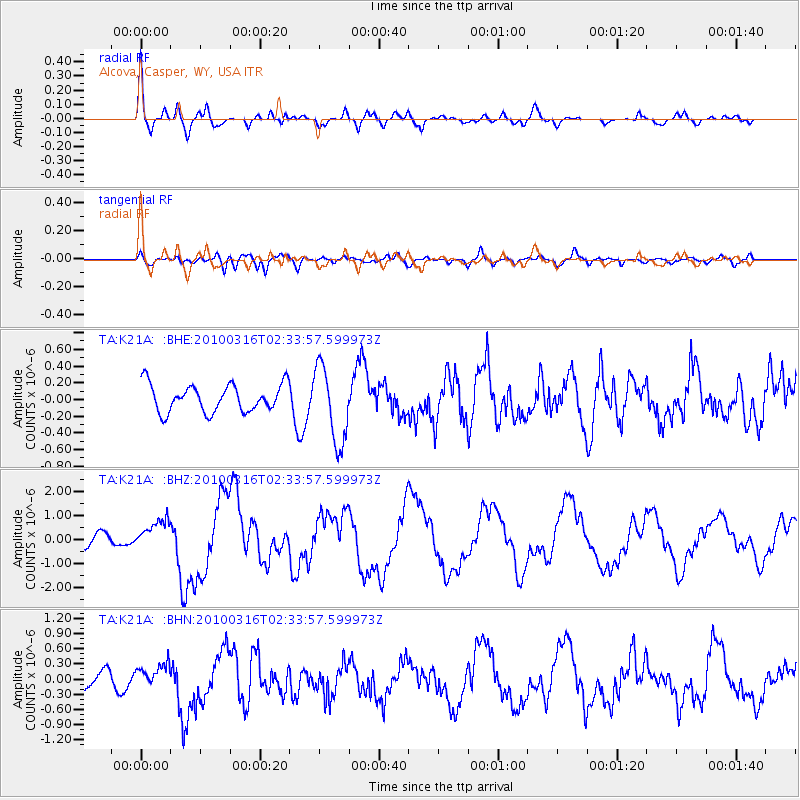
Signal To Noise
| Channel | StoN | STA | LTA |
| TA:K21A: :BHZ:20100316T02:33:57.599973Z | 3.1286116 | 6.0017214E-7 | 1.918334E-7 |
| TA:K21A: :BHN:20100316T02:33:57.599973Z | 1.1585768 | 2.3455854E-7 | 2.0245402E-7 |
| TA:K21A: :BHE:20100316T02:33:57.599973Z | 2.7932894 | 4.582738E-7 | 1.6406241E-7 |
| Arrivals |
| Ps | 6.2 SECOND |
| PpPs | 24 SECOND |
| PsPs/PpSs | 31 SECOND |


