You are here: Home > Network List > O2 - Oklahoma Consolidated Temporary Seismic Networks Stations List
> Station DOVR Dover, Oklahoma, USA > Earthquake Result Viewer
DOVR Dover, Oklahoma, USA - Earthquake Result Viewer
| Earthquake location: |
Tonga Islands |
| Earthquake latitude/longitude: |
-15.6/-174.6 |
| Earthquake time(UTC): |
2023/05/10 (130) 16:02:00 GMT |
| Earthquake Depth: |
210 km |
| Earthquake Magnitude: |
7.6 mww |
| Earthquake Catalog/Contributor: |
NEIC PDE/us |
|
| Network: |
O2 Oklahoma Consolidated Temporary Seismic Networks |
| Station: |
DOVR Dover, Oklahoma, USA |
| Lat/Lon: |
35.95 N/97.99 W |
| Elevation: |
337 m |
|
| Distance: |
88.6 deg |
| Az: |
52.145 deg |
| Baz: |
249.678 deg |
| Ray Param: |
0.041999552 |
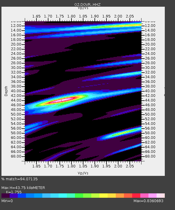
| Estimated Moho Depth: |
43.75 km |
| Estimated Crust Vp/Vs: |
1.75 |
| Assumed Crust Vp: |
6.426 km/s |
| Estimated Crust Vs: |
3.662 km/s |
| Estimated Crust Poisson's Ratio: |
0.26 |
|
| Radial Match: |
94.07135 % |
| Radial Bump: |
400 |
| Transverse Match: |
81.599174 % |
| Transverse Bump: |
400 |
| SOD ConfigId: |
30536071 |
| Insert Time: |
2023-05-24 16:29:11.032 +0000 |
| GWidth: |
2.5 |
| Max Bumps: |
400 |
| Tol: |
0.001 |
|

Signal To Noise
| Channel | StoN | STA | LTA |
| O2:DOVR: :HHZ:20230510T16:13:58.080028Z | 9.215216 | 3.8019366E-6 | 4.1257164E-7 |
| O2:DOVR: :HHN:20230510T16:13:58.080028Z | 1.4736534 | 7.018602E-7 | 4.7627222E-7 |
| O2:DOVR: :HHE:20230510T16:13:58.080028Z | 2.0082767 | 1.0666635E-6 | 5.311337E-7 |
| Arrivals |
| Ps | 5.3 SECOND |
| PpPs | 18 SECOND |
| PsPs/PpSs | 24 SECOND |


