You are here: Home > Network List > O2 - Oklahoma Consolidated Temporary Seismic Networks Stations List
> Station DUST Dustin, Oklahoma, USA > Earthquake Result Viewer
DUST Dustin, Oklahoma, USA - Earthquake Result Viewer
| Earthquake location: |
Tonga Islands |
| Earthquake latitude/longitude: |
-15.6/-174.6 |
| Earthquake time(UTC): |
2023/05/10 (130) 16:02:00 GMT |
| Earthquake Depth: |
210 km |
| Earthquake Magnitude: |
7.6 mww |
| Earthquake Catalog/Contributor: |
NEIC PDE/us |
|
| Network: |
O2 Oklahoma Consolidated Temporary Seismic Networks |
| Station: |
DUST Dustin, Oklahoma, USA |
| Lat/Lon: |
35.28 N/96.11 W |
| Elevation: |
268 m |
|
| Distance: |
89.8 deg |
| Az: |
53.296 deg |
| Baz: |
250.784 deg |
| Ray Param: |
0.041703135 |
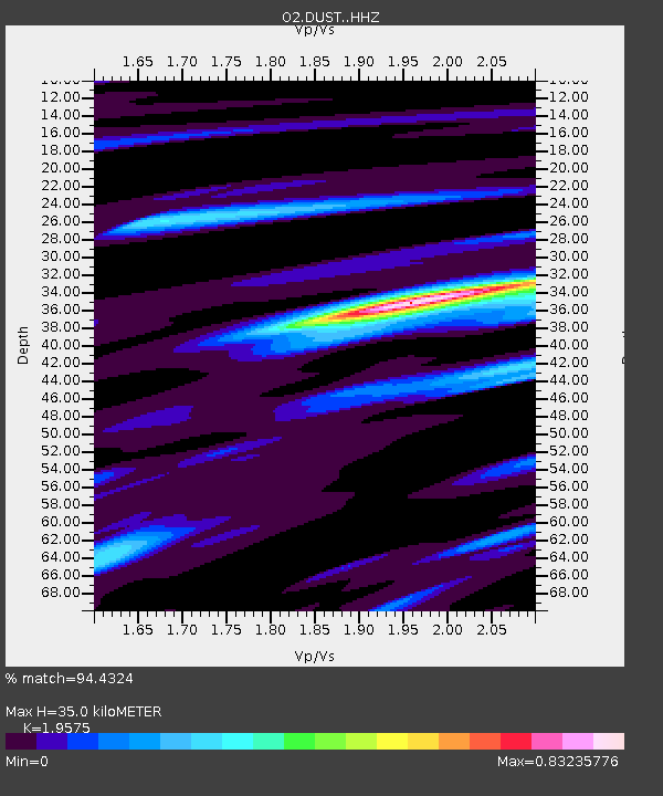
| Estimated Moho Depth: |
35.0 km |
| Estimated Crust Vp/Vs: |
1.96 |
| Assumed Crust Vp: |
6.426 km/s |
| Estimated Crust Vs: |
3.283 km/s |
| Estimated Crust Poisson's Ratio: |
0.32 |
|
| Radial Match: |
94.4324 % |
| Radial Bump: |
400 |
| Transverse Match: |
70.99186 % |
| Transverse Bump: |
400 |
| SOD ConfigId: |
30536071 |
| Insert Time: |
2023-05-24 16:29:14.178 +0000 |
| GWidth: |
2.5 |
| Max Bumps: |
400 |
| Tol: |
0.001 |
|

Signal To Noise
| Channel | StoN | STA | LTA |
| O2:DUST: :HHZ:20230510T16:14:03.700023Z | 11.678727 | 3.699913E-6 | 3.168079E-7 |
| O2:DUST: :HHN:20230510T16:14:03.700023Z | 1.3650239 | 5.098035E-7 | 3.7347587E-7 |
| O2:DUST: :HHE:20230510T16:14:03.700023Z | 4.1161213 | 1.0508907E-6 | 2.5531094E-7 |
| Arrivals |
| Ps | 5.3 SECOND |
| PpPs | 16 SECOND |
| PsPs/PpSs | 21 SECOND |


