You are here: Home > Network List > O2 - Oklahoma Consolidated Temporary Seismic Networks Stations List
> Station FW02 Waynoka, Oklahoma, USA > Earthquake Result Viewer
FW02 Waynoka, Oklahoma, USA - Earthquake Result Viewer
| Earthquake location: |
Tonga Islands |
| Earthquake latitude/longitude: |
-15.6/-174.6 |
| Earthquake time(UTC): |
2023/05/10 (130) 16:02:00 GMT |
| Earthquake Depth: |
210 km |
| Earthquake Magnitude: |
7.6 mww |
| Earthquake Catalog/Contributor: |
NEIC PDE/us |
|
| Network: |
O2 Oklahoma Consolidated Temporary Seismic Networks |
| Station: |
FW02 Waynoka, Oklahoma, USA |
| Lat/Lon: |
36.38 N/98.73 W |
| Elevation: |
434 m |
|
| Distance: |
88.2 deg |
| Az: |
51.538 deg |
| Baz: |
249.225 deg |
| Ray Param: |
0.04229221 |
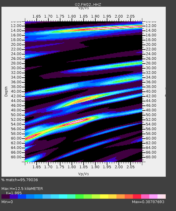
| Estimated Moho Depth: |
12.5 km |
| Estimated Crust Vp/Vs: |
2.00 |
| Assumed Crust Vp: |
6.426 km/s |
| Estimated Crust Vs: |
3.221 km/s |
| Estimated Crust Poisson's Ratio: |
0.33 |
|
| Radial Match: |
95.79036 % |
| Radial Bump: |
332 |
| Transverse Match: |
83.04156 % |
| Transverse Bump: |
400 |
| SOD ConfigId: |
30536071 |
| Insert Time: |
2023-05-24 16:29:20.240 +0000 |
| GWidth: |
2.5 |
| Max Bumps: |
400 |
| Tol: |
0.001 |
|

Signal To Noise
| Channel | StoN | STA | LTA |
| O2:FW02: :HHZ:20230510T16:13:56.140026Z | 8.857956 | 4.0786545E-6 | 4.6045102E-7 |
| O2:FW02: :HHN:20230510T16:13:56.140026Z | 2.1125436 | 1.0315013E-6 | 4.882745E-7 |
| O2:FW02: :HHE:20230510T16:13:56.140026Z | 2.565223 | 7.68786E-7 | 2.9969559E-7 |
| Arrivals |
| Ps | 2.0 SECOND |
| PpPs | 5.7 SECOND |
| PsPs/PpSs | 7.7 SECOND |


