You are here: Home > Network List > O2 - Oklahoma Consolidated Temporary Seismic Networks Stations List
> Station PW30 Pawnee, Oklahoma, USA > Earthquake Result Viewer
PW30 Pawnee, Oklahoma, USA - Earthquake Result Viewer
| Earthquake location: |
Tonga Islands |
| Earthquake latitude/longitude: |
-15.6/-174.6 |
| Earthquake time(UTC): |
2023/05/10 (130) 16:02:00 GMT |
| Earthquake Depth: |
210 km |
| Earthquake Magnitude: |
7.6 mww |
| Earthquake Catalog/Contributor: |
NEIC PDE/us |
|
| Network: |
O2 Oklahoma Consolidated Temporary Seismic Networks |
| Station: |
PW30 Pawnee, Oklahoma, USA |
| Lat/Lon: |
36.42 N/96.82 W |
| Elevation: |
314 m |
|
| Distance: |
89.6 deg |
| Az: |
52.034 deg |
| Baz: |
250.362 deg |
| Ray Param: |
0.041713446 |
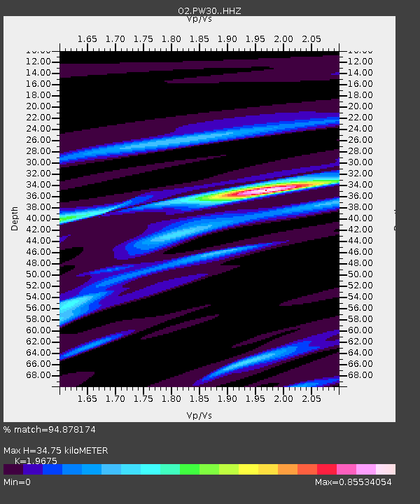
| Estimated Moho Depth: |
34.75 km |
| Estimated Crust Vp/Vs: |
1.97 |
| Assumed Crust Vp: |
6.483 km/s |
| Estimated Crust Vs: |
3.295 km/s |
| Estimated Crust Poisson's Ratio: |
0.33 |
|
| Radial Match: |
94.878174 % |
| Radial Bump: |
225 |
| Transverse Match: |
46.332577 % |
| Transverse Bump: |
400 |
| SOD ConfigId: |
30536071 |
| Insert Time: |
2023-05-24 16:29:50.628 +0000 |
| GWidth: |
2.5 |
| Max Bumps: |
400 |
| Tol: |
0.001 |
|

Signal To Noise
| Channel | StoN | STA | LTA |
| O2:PW30: :HHZ:20230510T16:14:02.919994Z | 5.967169 | 2.564496E-6 | 4.2976765E-7 |
| O2:PW30: :HHN:20230510T16:14:02.919994Z | 2.3242288 | 1.8157378E-6 | 7.812217E-7 |
| O2:PW30: :HHE:20230510T16:14:02.919994Z | 1.8817934 | 1.0732034E-6 | 5.703089E-7 |
| Arrivals |
| Ps | 5.3 SECOND |
| PpPs | 16 SECOND |
| PsPs/PpSs | 21 SECOND |


