You are here: Home > Network List > O2 - Oklahoma Consolidated Temporary Seismic Networks Stations List
> Station SC15 Hammon, Oklahoma, USA > Earthquake Result Viewer
SC15 Hammon, Oklahoma, USA - Earthquake Result Viewer
| Earthquake location: |
Tonga Islands |
| Earthquake latitude/longitude: |
-15.6/-174.6 |
| Earthquake time(UTC): |
2023/05/10 (130) 16:02:00 GMT |
| Earthquake Depth: |
210 km |
| Earthquake Magnitude: |
7.6 mww |
| Earthquake Catalog/Contributor: |
NEIC PDE/us |
|
| Network: |
O2 Oklahoma Consolidated Temporary Seismic Networks |
| Station: |
SC15 Hammon, Oklahoma, USA |
| Lat/Lon: |
35.61 N/99.50 W |
| Elevation: |
550 m |
|
| Distance: |
87.3 deg |
| Az: |
52.034 deg |
| Baz: |
248.794 deg |
| Ray Param: |
0.042926725 |
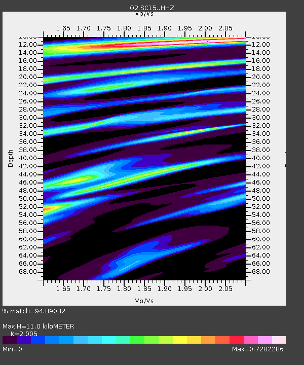
| Estimated Moho Depth: |
11.0 km |
| Estimated Crust Vp/Vs: |
2.01 |
| Assumed Crust Vp: |
6.315 km/s |
| Estimated Crust Vs: |
3.15 km/s |
| Estimated Crust Poisson's Ratio: |
0.33 |
|
| Radial Match: |
94.89032 % |
| Radial Bump: |
400 |
| Transverse Match: |
79.7588 % |
| Transverse Bump: |
400 |
| SOD ConfigId: |
30536071 |
| Insert Time: |
2023-05-24 16:30:17.566 +0000 |
| GWidth: |
2.5 |
| Max Bumps: |
400 |
| Tol: |
0.001 |
|

Signal To Noise
| Channel | StoN | STA | LTA |
| O2:SC15: :HHZ:20230510T16:13:52.075023Z | 3.0009675 | 5.23804E-6 | 1.7454504E-6 |
| O2:SC15: :HHN:20230510T16:13:52.075023Z | 0.94182134 | 9.03199E-7 | 9.589918E-7 |
| O2:SC15: :HHE:20230510T16:13:52.075023Z | 3.0726626 | 2.2948577E-6 | 7.468629E-7 |
| Arrivals |
| Ps | 1.8 SECOND |
| PpPs | 5.1 SECOND |
| PsPs/PpSs | 6.9 SECOND |


