You are here: Home > Network List > TA - USArray Transportable Network (new EarthScope stations) Stations List
> Station H19A Powell, WY, USA > Earthquake Result Viewer
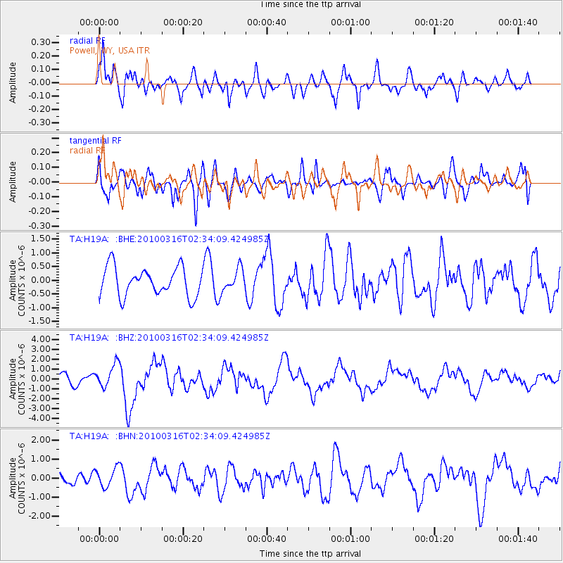
H19A Powell, WY, USA - Earthquake Result Viewer
*The percent match for this event was below the threshold and hence no stack was calculated.
| Earthquake location: |
Near Coast Of Central Chile |
| Earthquake latitude/longitude: |
-36.2/-73.3 |
| Earthquake time(UTC): |
2010/03/16 (075) 02:21:57 GMT |
| Earthquake Depth: |
18 km |
| Earthquake Magnitude: |
6.0 MB, 6.7 MS, 6.7 MW, 6.6 MW |
| Earthquake Catalog/Contributor: |
WHDF/NEIC |
|
| Network: |
TA USArray Transportable Network (new EarthScope stations) |
| Station: |
H19A Powell, WY, USA |
| Lat/Lon: |
44.67 N/108.99 W |
| Elevation: |
1479 m |
|
| Distance: |
86.8 deg |
| Az: |
335.335 deg |
| Baz: |
151.773 deg |
| Ray Param: |
$rayparam |
*The percent match for this event was below the threshold and hence was not used in the summary stack. |
|
| Radial Match: |
82.19318 % |
| Radial Bump: |
400 |
| Transverse Match: |
56.186222 % |
| Transverse Bump: |
400 |
| SOD ConfigId: |
308276 |
| Insert Time: |
2010-06-22 20:14:05.853 +0000 |
| GWidth: |
2.5 |
| Max Bumps: |
400 |
| Tol: |
0.001 |
|
Signal To Noise
| Channel | StoN | STA | LTA |
| TA:H19A: :BHZ:20100316T02:34:09.424985Z | 2.8505192 | 1.2227357E-6 | 4.2895192E-7 |
| TA:H19A: :BHN:20100316T02:34:09.424985Z | 1.93144 | 5.0982953E-7 | 2.6396341E-7 |
| TA:H19A: :BHE:20100316T02:34:09.424985Z | 0.75743824 | 3.9415403E-7 | 5.203778E-7 |
| Arrivals |
| Ps | |
| PpPs | |
| PsPs/PpSs | |


