You are here: Home > Network List > OK - Oklahoma Seismic Network Stations List
> Station CHOK Chandler, Oklahoma, USA > Earthquake Result Viewer
CHOK Chandler, Oklahoma, USA - Earthquake Result Viewer
| Earthquake location: |
Tonga Islands |
| Earthquake latitude/longitude: |
-15.6/-174.6 |
| Earthquake time(UTC): |
2023/05/10 (130) 16:02:00 GMT |
| Earthquake Depth: |
210 km |
| Earthquake Magnitude: |
7.6 mww |
| Earthquake Catalog/Contributor: |
NEIC PDE/us |
|
| Network: |
OK Oklahoma Seismic Network |
| Station: |
CHOK Chandler, Oklahoma, USA |
| Lat/Lon: |
35.56 N/97.06 W |
| Elevation: |
338 m |
|
| Distance: |
89.2 deg |
| Az: |
52.772 deg |
| Baz: |
250.23 deg |
| Ray Param: |
0.04173119 |
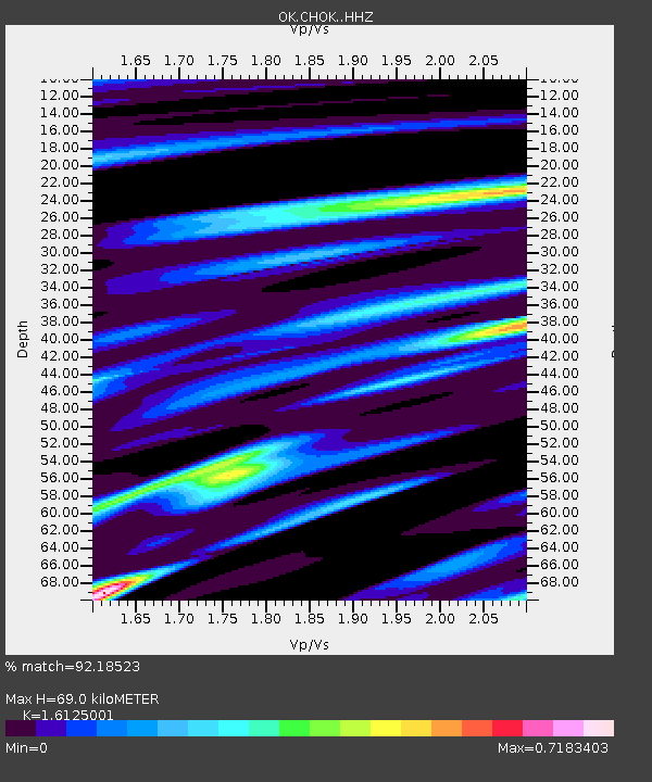
| Estimated Moho Depth: |
69.0 km |
| Estimated Crust Vp/Vs: |
1.61 |
| Assumed Crust Vp: |
6.426 km/s |
| Estimated Crust Vs: |
3.985 km/s |
| Estimated Crust Poisson's Ratio: |
0.19 |
|
| Radial Match: |
92.18523 % |
| Radial Bump: |
400 |
| Transverse Match: |
53.882343 % |
| Transverse Bump: |
400 |
| SOD ConfigId: |
30536071 |
| Insert Time: |
2023-05-24 16:30:41.387 +0000 |
| GWidth: |
2.5 |
| Max Bumps: |
400 |
| Tol: |
0.001 |
|

Signal To Noise
| Channel | StoN | STA | LTA |
| OK:CHOK: :HHZ:20230510T16:14:00.734997Z | 7.5318627 | 3.327096E-6 | 4.4173615E-7 |
| OK:CHOK: :HHN:20230510T16:14:00.734997Z | 0.72089 | 3.908683E-7 | 5.4220243E-7 |
| OK:CHOK: :HHE:20230510T16:14:00.734997Z | 2.5317085 | 1.5909458E-6 | 6.28408E-7 |
| Arrivals |
| Ps | 6.7 SECOND |
| PpPs | 27 SECOND |
| PsPs/PpSs | 34 SECOND |


