You are here: Home > Network List > PB - Plate Boundary Observatory Borehole Seismic Network Stations List
> Station B084 pinyon084bcs2006, Anza, CA, USA > Earthquake Result Viewer
B084 pinyon084bcs2006, Anza, CA, USA - Earthquake Result Viewer
| Earthquake location: |
Tonga Islands |
| Earthquake latitude/longitude: |
-15.6/-174.6 |
| Earthquake time(UTC): |
2023/05/10 (130) 16:02:00 GMT |
| Earthquake Depth: |
210 km |
| Earthquake Magnitude: |
7.6 mww |
| Earthquake Catalog/Contributor: |
NEIC PDE/us |
|
| Network: |
PB Plate Boundary Observatory Borehole Seismic Network |
| Station: |
B084 pinyon084bcs2006, Anza, CA, USA |
| Lat/Lon: |
33.61 N/116.46 W |
| Elevation: |
1271 m |
|
| Distance: |
73.9 deg |
| Az: |
47.541 deg |
| Baz: |
238.419 deg |
| Ray Param: |
0.052123208 |
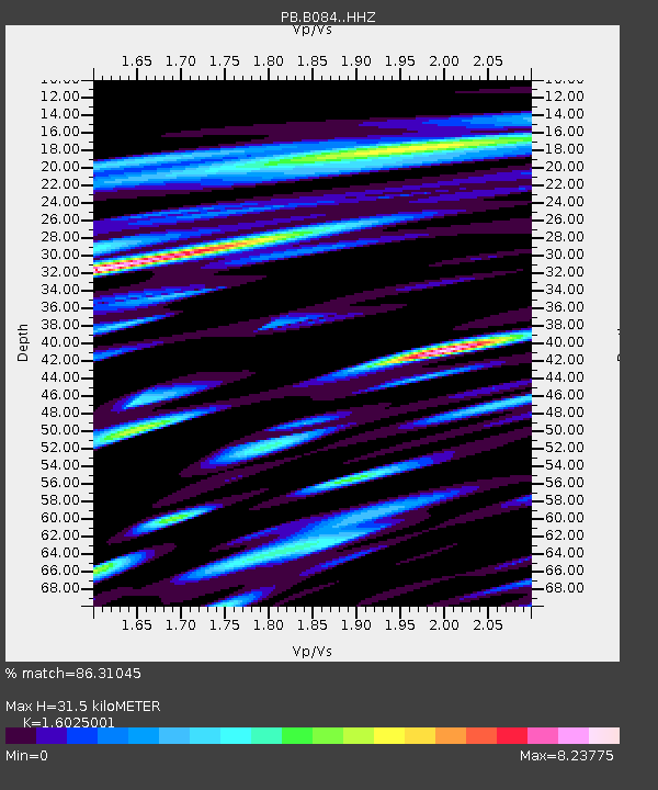
| Estimated Moho Depth: |
31.5 km |
| Estimated Crust Vp/Vs: |
1.60 |
| Assumed Crust Vp: |
6.264 km/s |
| Estimated Crust Vs: |
3.909 km/s |
| Estimated Crust Poisson's Ratio: |
0.18 |
|
| Radial Match: |
86.31045 % |
| Radial Bump: |
400 |
| Transverse Match: |
81.80689 % |
| Transverse Bump: |
400 |
| SOD ConfigId: |
30536071 |
| Insert Time: |
2023-05-24 16:31:30.371 +0000 |
| GWidth: |
2.5 |
| Max Bumps: |
400 |
| Tol: |
0.001 |
|

Signal To Noise
| Channel | StoN | STA | LTA |
| PB:B084: :HHZ:20230510T16:12:41.34901Z | 4.4618106 | 4.6304343E-9 | 1.0377926E-9 |
| PB:B084: :HH1:20230510T16:12:41.34901Z | 5.138456 | 1.6315463E-8 | 3.1751686E-9 |
| PB:B084: :HH2:20230510T16:12:41.34901Z | 1.1241337 | 3.829469E-9 | 3.406596E-9 |
| Arrivals |
| Ps | 3.1 SECOND |
| PpPs | 13 SECOND |
| PsPs/PpSs | 16 SECOND |


