You are here: Home > Network List > TM - Thai Seismic Monitoring Network Stations List
> Station SURA Don Sak, Surat Thani > Earthquake Result Viewer
SURA Don Sak, Surat Thani - Earthquake Result Viewer
| Earthquake location: |
Tonga Islands |
| Earthquake latitude/longitude: |
-15.6/-174.6 |
| Earthquake time(UTC): |
2023/05/10 (130) 16:02:00 GMT |
| Earthquake Depth: |
210 km |
| Earthquake Magnitude: |
7.6 mww |
| Earthquake Catalog/Contributor: |
NEIC PDE/us |
|
| Network: |
TM Thai Seismic Monitoring Network |
| Station: |
SURA Don Sak, Surat Thani |
| Lat/Lon: |
9.17 N/99.63 E |
| Elevation: |
18 m |
|
| Distance: |
88.4 deg |
| Az: |
279.908 deg |
| Baz: |
105.977 deg |
| Ray Param: |
0.042136297 |
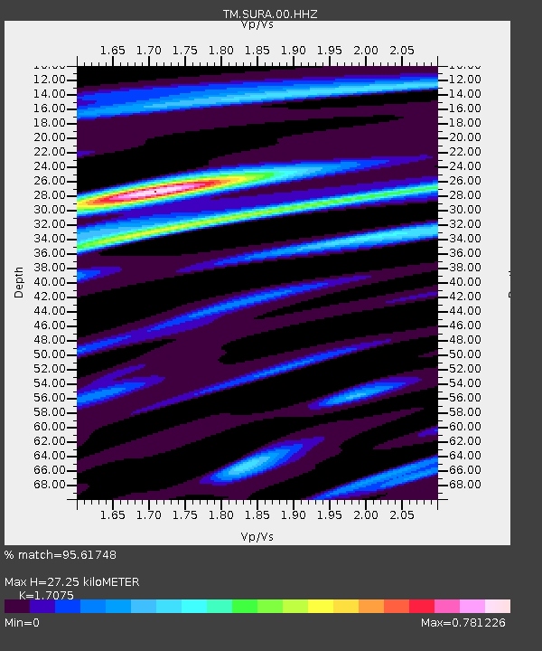
| Estimated Moho Depth: |
27.25 km |
| Estimated Crust Vp/Vs: |
1.71 |
| Assumed Crust Vp: |
6.468 km/s |
| Estimated Crust Vs: |
3.788 km/s |
| Estimated Crust Poisson's Ratio: |
0.24 |
|
| Radial Match: |
95.61748 % |
| Radial Bump: |
400 |
| Transverse Match: |
82.9209 % |
| Transverse Bump: |
400 |
| SOD ConfigId: |
30536071 |
| Insert Time: |
2023-05-24 16:35:45.511 +0000 |
| GWidth: |
2.5 |
| Max Bumps: |
400 |
| Tol: |
0.001 |
|

Signal To Noise
| Channel | StoN | STA | LTA |
| TM:SURA:00:HHZ:20230510T16:13:57.190014Z | 1.326955 | 4.1790543E-7 | 3.1493565E-7 |
| TM:SURA:00:HHN:20230510T16:13:57.190014Z | 0.98209393 | 1.6947348E-7 | 1.7256342E-7 |
| TM:SURA:00:HHE:20230510T16:13:57.190014Z | 1.5370185 | 2.4837473E-7 | 1.6159514E-7 |
| Arrivals |
| Ps | 3.0 SECOND |
| PpPs | 11 SECOND |
| PsPs/PpSs | 14 SECOND |


