You are here: Home > Network List > TX - Texas Seismological Network Stations List
> Station MB10 Stanton > Earthquake Result Viewer
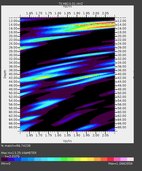
MB10 Stanton - Earthquake Result Viewer
| Earthquake location: |
Tonga Islands |
| Earthquake latitude/longitude: |
-15.6/-174.6 |
| Earthquake time(UTC): |
2023/05/10 (130) 16:02:00 GMT |
| Earthquake Depth: |
210 km |
| Earthquake Magnitude: |
7.6 mww |
| Earthquake Catalog/Contributor: |
NEIC PDE/us |
|
| Network: |
TX Texas Seismological Network |
| Station: |
MB10 Stanton |
| Lat/Lon: |
32.27 N/101.79 W |
| Elevation: |
813 m |
|
| Distance: |
84.3 deg |
| Az: |
54.429 deg |
| Baz: |
247.695 deg |
| Ray Param: |
0.045071155 |
| Estimated Moho Depth: |
13.25 km |
| Estimated Crust Vp/Vs: |
2.04 |
| Assumed Crust Vp: |
6.426 km/s |
| Estimated Crust Vs: |
3.154 km/s |
| Estimated Crust Poisson's Ratio: |
0.34 |
|
| Radial Match: |
96.74239 % |
| Radial Bump: |
400 |
| Transverse Match: |
91.474495 % |
| Transverse Bump: |
400 |
| SOD ConfigId: |
30536071 |
| Insert Time: |
2023-05-24 16:36:28.873 +0000 |
| GWidth: |
2.5 |
| Max Bumps: |
400 |
| Tol: |
0.001 |
|

Signal To Noise
| Channel | StoN | STA | LTA |
| TX:MB10:01:HHZ:20230510T16:13:37.39497Z | 35.44033 | 6.0270813E-6 | 1.7006279E-7 |
| TX:MB10:01:HHN:20230510T16:13:37.39497Z | 2.944567 | 9.846741E-7 | 3.3440372E-7 |
| TX:MB10:01:HHE:20230510T16:13:37.39497Z | 4.9893346 | 1.8540883E-6 | 3.7161033E-7 |
| Arrivals |
| Ps | 2.2 SECOND |
| PpPs | 6.1 SECOND |
| PsPs/PpSs | 8.3 SECOND |


