You are here: Home > Network List > TX - Texas Seismological Network Stations List
> Station PB03 Z > Earthquake Result Viewer
PB03 Z - Earthquake Result Viewer
| Earthquake location: |
Tonga Islands |
| Earthquake latitude/longitude: |
-15.6/-174.6 |
| Earthquake time(UTC): |
2023/05/10 (130) 16:02:00 GMT |
| Earthquake Depth: |
210 km |
| Earthquake Magnitude: |
7.6 mww |
| Earthquake Catalog/Contributor: |
NEIC PDE/us |
|
| Network: |
TX Texas Seismological Network |
| Station: |
PB03 Z |
| Lat/Lon: |
31.08 N/103.51 W |
| Elevation: |
817 m |
|
| Distance: |
82.5 deg |
| Az: |
54.951 deg |
| Baz: |
246.855 deg |
| Ray Param: |
0.046336543 |
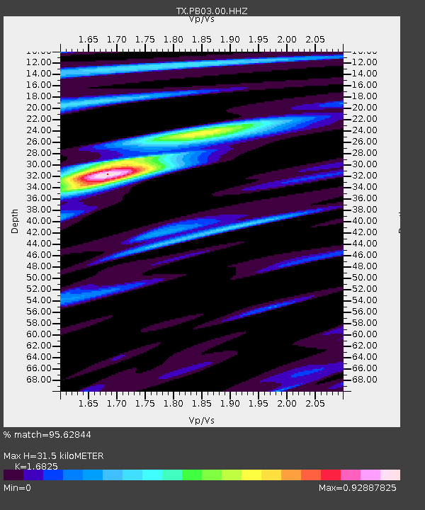
| Estimated Moho Depth: |
31.5 km |
| Estimated Crust Vp/Vs: |
1.68 |
| Assumed Crust Vp: |
6.121 km/s |
| Estimated Crust Vs: |
3.638 km/s |
| Estimated Crust Poisson's Ratio: |
0.23 |
|
| Radial Match: |
95.62844 % |
| Radial Bump: |
400 |
| Transverse Match: |
86.5567 % |
| Transverse Bump: |
400 |
| SOD ConfigId: |
30536071 |
| Insert Time: |
2023-05-24 16:36:39.183 +0000 |
| GWidth: |
2.5 |
| Max Bumps: |
400 |
| Tol: |
0.001 |
|

Signal To Noise
| Channel | StoN | STA | LTA |
| TX:PB03:00:HHZ:20230510T16:13:28.219982Z | 11.236783 | 2.7122485E-6 | 2.413723E-7 |
| TX:PB03:00:HH1:20230510T16:13:28.219982Z | 1.8812517 | 4.3848942E-7 | 2.3308387E-7 |
| TX:PB03:00:HH2:20230510T16:13:28.219982Z | 2.0668046 | 6.034356E-7 | 2.9196545E-7 |
| Arrivals |
| Ps | 3.6 SECOND |
| PpPs | 13 SECOND |
| PsPs/PpSs | 17 SECOND |


