You are here: Home > Network List > TX - Texas Seismological Network Stations List
> Station PB16 Coyonosa > Earthquake Result Viewer
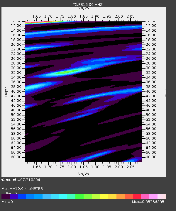
PB16 Coyonosa - Earthquake Result Viewer
| Earthquake location: |
Tonga Islands |
| Earthquake latitude/longitude: |
-15.6/-174.6 |
| Earthquake time(UTC): |
2023/05/10 (130) 16:02:00 GMT |
| Earthquake Depth: |
210 km |
| Earthquake Magnitude: |
7.6 mww |
| Earthquake Catalog/Contributor: |
NEIC PDE/us |
|
| Network: |
TX Texas Seismological Network |
| Station: |
PB16 Coyonosa |
| Lat/Lon: |
31.12 N/103.25 W |
| Elevation: |
848 m |
|
| Distance: |
82.7 deg |
| Az: |
55.002 deg |
| Baz: |
246.996 deg |
| Ray Param: |
0.046182573 |
| Estimated Moho Depth: |
10.0 km |
| Estimated Crust Vp/Vs: |
1.60 |
| Assumed Crust Vp: |
6.121 km/s |
| Estimated Crust Vs: |
3.825 km/s |
| Estimated Crust Poisson's Ratio: |
0.18 |
|
| Radial Match: |
97.710304 % |
| Radial Bump: |
400 |
| Transverse Match: |
86.34525 % |
| Transverse Bump: |
400 |
| SOD ConfigId: |
30536071 |
| Insert Time: |
2023-05-24 16:36:58.545 +0000 |
| GWidth: |
2.5 |
| Max Bumps: |
400 |
| Tol: |
0.001 |
|

Signal To Noise
| Channel | StoN | STA | LTA |
| TX:PB16:00:HHZ:20230510T16:13:29.370006Z | 11.82595 | 3.280944E-6 | 2.77436E-7 |
| TX:PB16:00:HH1:20230510T16:13:29.370006Z | 1.6353195 | 3.1011527E-7 | 1.8963588E-7 |
| TX:PB16:00:HH2:20230510T16:13:29.370006Z | 1.4953953 | 5.5827206E-7 | 3.7332742E-7 |
| Arrivals |
| Ps | 1.0 SECOND |
| PpPs | 4.1 SECOND |
| PsPs/PpSs | 5.1 SECOND |


