You are here: Home > Network List > TX - Texas Seismological Network Stations List
> Station PB21 Reeves Ward Border > Earthquake Result Viewer
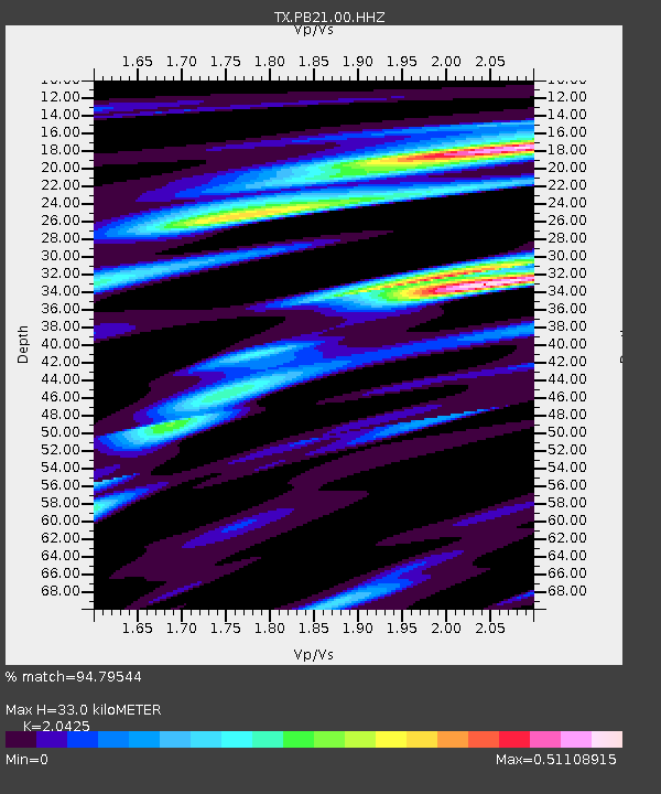
PB21 Reeves Ward Border - Earthquake Result Viewer
| Earthquake location: |
Tonga Islands |
| Earthquake latitude/longitude: |
-15.6/-174.6 |
| Earthquake time(UTC): |
2023/05/10 (130) 16:02:00 GMT |
| Earthquake Depth: |
210 km |
| Earthquake Magnitude: |
7.6 mww |
| Earthquake Catalog/Contributor: |
NEIC PDE/us |
|
| Network: |
TX Texas Seismological Network |
| Station: |
PB21 Reeves Ward Border |
| Lat/Lon: |
31.34 N/103.06 W |
| Elevation: |
753 m |
|
| Distance: |
83.0 deg |
| Az: |
54.865 deg |
| Baz: |
247.077 deg |
| Ray Param: |
0.04601727 |
| Estimated Moho Depth: |
33.0 km |
| Estimated Crust Vp/Vs: |
2.04 |
| Assumed Crust Vp: |
6.121 km/s |
| Estimated Crust Vs: |
2.997 km/s |
| Estimated Crust Poisson's Ratio: |
0.34 |
|
| Radial Match: |
94.79544 % |
| Radial Bump: |
391 |
| Transverse Match: |
77.61127 % |
| Transverse Bump: |
400 |
| SOD ConfigId: |
30536071 |
| Insert Time: |
2023-05-24 16:37:01.741 +0000 |
| GWidth: |
2.5 |
| Max Bumps: |
400 |
| Tol: |
0.001 |
|

Signal To Noise
| Channel | StoN | STA | LTA |
| TX:PB21:00:HHZ:20230510T16:13:30.560009Z | 8.310805 | 3.2832884E-6 | 3.9506259E-7 |
| TX:PB21:00:HH1:20230510T16:13:30.560009Z | 1.2000153 | 5.113557E-7 | 4.2612436E-7 |
| TX:PB21:00:HH2:20230510T16:13:30.560009Z | 2.8898816 | 7.198986E-7 | 2.4911006E-7 |
| Arrivals |
| Ps | 5.7 SECOND |
| PpPs | 16 SECOND |
| PsPs/PpSs | 22 SECOND |


