You are here: Home > Network List > UO - University of Oregon Regional Network Stations List
> Station MONKS Deer Island, OR, USA > Earthquake Result Viewer
MONKS Deer Island, OR, USA - Earthquake Result Viewer
| Earthquake location: |
Tonga Islands |
| Earthquake latitude/longitude: |
-15.6/-174.6 |
| Earthquake time(UTC): |
2023/05/10 (130) 16:02:00 GMT |
| Earthquake Depth: |
210 km |
| Earthquake Magnitude: |
7.6 mww |
| Earthquake Catalog/Contributor: |
NEIC PDE/us |
|
| Network: |
UO University of Oregon Regional Network |
| Station: |
MONKS Deer Island, OR, USA |
| Lat/Lon: |
45.99 N/123.00 W |
| Elevation: |
380 m |
|
| Distance: |
77.0 deg |
| Az: |
34.114 deg |
| Baz: |
230.825 deg |
| Ray Param: |
0.050111204 |
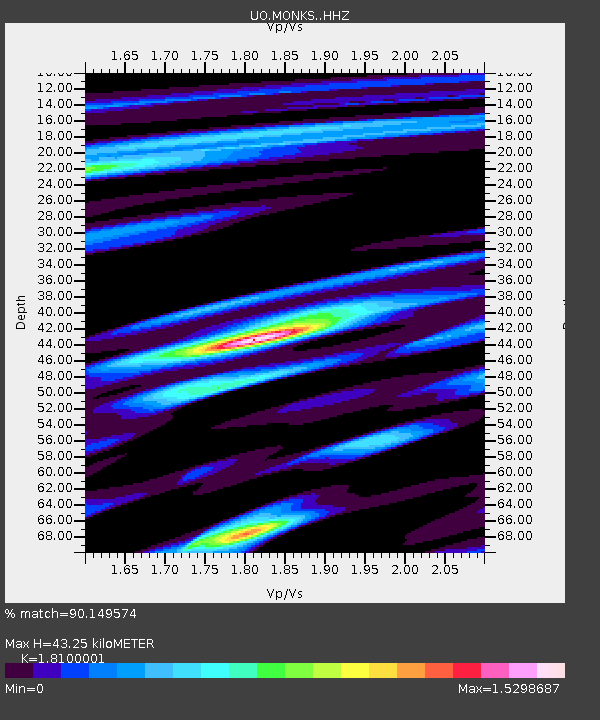
| Estimated Moho Depth: |
43.25 km |
| Estimated Crust Vp/Vs: |
1.81 |
| Assumed Crust Vp: |
6.566 km/s |
| Estimated Crust Vs: |
3.628 km/s |
| Estimated Crust Poisson's Ratio: |
0.28 |
|
| Radial Match: |
90.149574 % |
| Radial Bump: |
400 |
| Transverse Match: |
81.73696 % |
| Transverse Bump: |
400 |
| SOD ConfigId: |
30536071 |
| Insert Time: |
2023-05-24 16:38:27.330 +0000 |
| GWidth: |
2.5 |
| Max Bumps: |
400 |
| Tol: |
0.001 |
|

Signal To Noise
| Channel | StoN | STA | LTA |
| UO:MONKS: :HHZ:20230510T16:12:58.609997Z | 29.482101 | 7.157608E-6 | 2.427781E-7 |
| UO:MONKS: :HHN:20230510T16:12:58.609997Z | 2.3673234 | 9.0776007E-7 | 3.834542E-7 |
| UO:MONKS: :HHE:20230510T16:12:58.609997Z | 4.073349 | 1.189173E-6 | 2.9193987E-7 |
| Arrivals |
| Ps | 5.5 SECOND |
| PpPs | 18 SECOND |
| PsPs/PpSs | 23 SECOND |


