You are here: Home > Network List > UO - University of Oregon Regional Network Stations List
> Station TDWTR Tidewater, OR, USA > Earthquake Result Viewer
TDWTR Tidewater, OR, USA - Earthquake Result Viewer
| Earthquake location: |
Tonga Islands |
| Earthquake latitude/longitude: |
-15.6/-174.6 |
| Earthquake time(UTC): |
2023/05/10 (130) 16:02:00 GMT |
| Earthquake Depth: |
210 km |
| Earthquake Magnitude: |
7.6 mww |
| Earthquake Catalog/Contributor: |
NEIC PDE/us |
|
| Network: |
UO University of Oregon Regional Network |
| Station: |
TDWTR Tidewater, OR, USA |
| Lat/Lon: |
44.35 N/123.89 W |
| Elevation: |
594 m |
|
| Distance: |
75.4 deg |
| Az: |
35.016 deg |
| Baz: |
230.416 deg |
| Ray Param: |
0.051120922 |
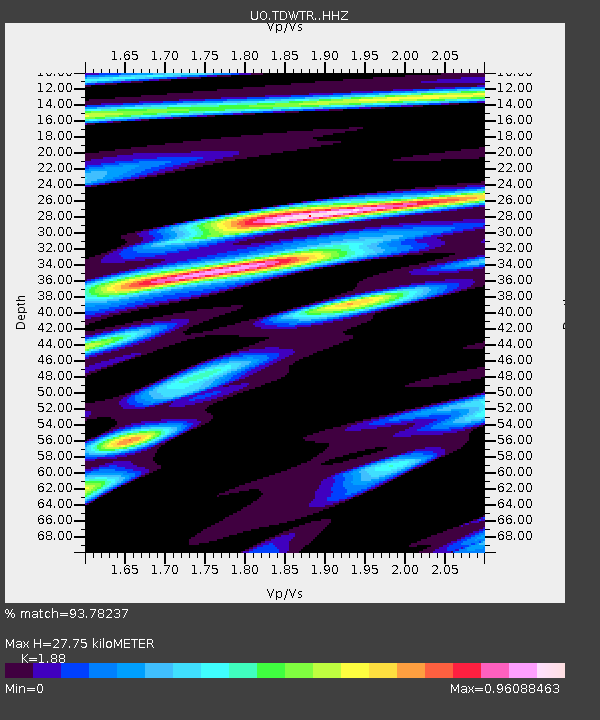
| Estimated Moho Depth: |
27.75 km |
| Estimated Crust Vp/Vs: |
1.88 |
| Assumed Crust Vp: |
6.566 km/s |
| Estimated Crust Vs: |
3.493 km/s |
| Estimated Crust Poisson's Ratio: |
0.30 |
|
| Radial Match: |
93.78237 % |
| Radial Bump: |
400 |
| Transverse Match: |
85.03307 % |
| Transverse Bump: |
400 |
| SOD ConfigId: |
30536071 |
| Insert Time: |
2023-05-24 16:38:56.348 +0000 |
| GWidth: |
2.5 |
| Max Bumps: |
400 |
| Tol: |
0.001 |
|

Signal To Noise
| Channel | StoN | STA | LTA |
| UO:TDWTR: :HHZ:20230510T16:12:50.049999Z | 22.127903 | 8.44358E-6 | 3.815806E-7 |
| UO:TDWTR: :HHN:20230510T16:12:50.049999Z | 4.5516925 | 2.116837E-6 | 4.650659E-7 |
| UO:TDWTR: :HHE:20230510T16:12:50.049999Z | 6.085525 | 2.402522E-6 | 3.9479286E-7 |
| Arrivals |
| Ps | 3.8 SECOND |
| PpPs | 12 SECOND |
| PsPs/PpSs | 16 SECOND |


