You are here: Home > Network List > UO - University of Oregon Regional Network Stations List
> Station TOOM Fort Rock, OR, USA > Earthquake Result Viewer
TOOM Fort Rock, OR, USA - Earthquake Result Viewer
| Earthquake location: |
Tonga Islands |
| Earthquake latitude/longitude: |
-15.6/-174.6 |
| Earthquake time(UTC): |
2023/05/10 (130) 16:02:00 GMT |
| Earthquake Depth: |
210 km |
| Earthquake Magnitude: |
7.6 mww |
| Earthquake Catalog/Contributor: |
NEIC PDE/us |
|
| Network: |
UO University of Oregon Regional Network |
| Station: |
TOOM Fort Rock, OR, USA |
| Lat/Lon: |
43.28 N/121.23 W |
| Elevation: |
1541 m |
|
| Distance: |
76.3 deg |
| Az: |
37.105 deg |
| Baz: |
232.757 deg |
| Ray Param: |
0.050557934 |
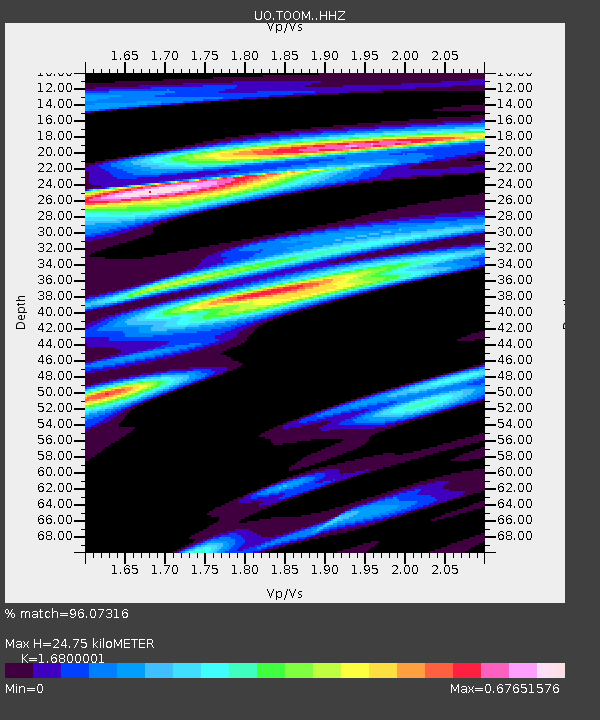
| Estimated Moho Depth: |
24.75 km |
| Estimated Crust Vp/Vs: |
1.68 |
| Assumed Crust Vp: |
6.597 km/s |
| Estimated Crust Vs: |
3.927 km/s |
| Estimated Crust Poisson's Ratio: |
0.23 |
|
| Radial Match: |
96.07316 % |
| Radial Bump: |
400 |
| Transverse Match: |
74.49194 % |
| Transverse Bump: |
400 |
| SOD ConfigId: |
30536071 |
| Insert Time: |
2023-05-24 16:38:57.881 +0000 |
| GWidth: |
2.5 |
| Max Bumps: |
400 |
| Tol: |
0.001 |
|

Signal To Noise
| Channel | StoN | STA | LTA |
| UO:TOOM: :HHZ:20230510T16:12:54.799999Z | 22.432684 | 5.7256543E-6 | 2.5523715E-7 |
| UO:TOOM: :HHN:20230510T16:12:54.799999Z | 4.042478 | 8.320568E-7 | 2.058284E-7 |
| UO:TOOM: :HHE:20230510T16:12:54.799999Z | 6.95168 | 1.4200372E-6 | 2.042725E-7 |
| Arrivals |
| Ps | 2.6 SECOND |
| PpPs | 9.7 SECOND |
| PsPs/PpSs | 12 SECOND |


