You are here: Home > Network List > US - United States National Seismic Network Stations List
> Station CBKS Cedar Bluff, Kansas, USA > Earthquake Result Viewer
CBKS Cedar Bluff, Kansas, USA - Earthquake Result Viewer
| Earthquake location: |
Tonga Islands |
| Earthquake latitude/longitude: |
-15.6/-174.6 |
| Earthquake time(UTC): |
2023/05/10 (130) 16:02:00 GMT |
| Earthquake Depth: |
210 km |
| Earthquake Magnitude: |
7.6 mww |
| Earthquake Catalog/Contributor: |
NEIC PDE/us |
|
| Network: |
US United States National Seismic Network |
| Station: |
CBKS Cedar Bluff, Kansas, USA |
| Lat/Lon: |
38.81 N/99.74 W |
| Elevation: |
677 m |
|
| Distance: |
88.3 deg |
| Az: |
48.981 deg |
| Baz: |
248.534 deg |
| Ray Param: |
0.04220372 |
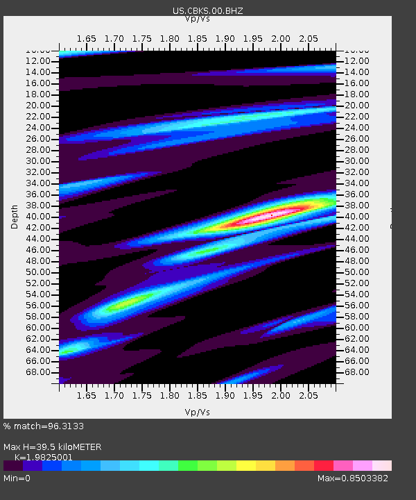
| Estimated Moho Depth: |
39.5 km |
| Estimated Crust Vp/Vs: |
1.98 |
| Assumed Crust Vp: |
6.483 km/s |
| Estimated Crust Vs: |
3.27 km/s |
| Estimated Crust Poisson's Ratio: |
0.33 |
|
| Radial Match: |
96.3133 % |
| Radial Bump: |
400 |
| Transverse Match: |
82.32926 % |
| Transverse Bump: |
400 |
| SOD ConfigId: |
30536071 |
| Insert Time: |
2023-05-24 16:39:31.277 +0000 |
| GWidth: |
2.5 |
| Max Bumps: |
400 |
| Tol: |
0.001 |
|

Signal To Noise
| Channel | StoN | STA | LTA |
| US:CBKS:00:BHZ:20230510T16:13:56.750011Z | 14.111938 | 3.8453372E-6 | 2.7248825E-7 |
| US:CBKS:00:BH1:20230510T16:13:56.750011Z | 1.1253749 | 4.0573602E-7 | 3.605341E-7 |
| US:CBKS:00:BH2:20230510T16:13:56.750011Z | 3.4563482 | 1.2457385E-6 | 3.6042044E-7 |
| Arrivals |
| Ps | 6.1 SECOND |
| PpPs | 18 SECOND |
| PsPs/PpSs | 24 SECOND |


