You are here: Home > Network List > UU - University of Utah Regional Network Stations List
> Station FOR8 FORGE > Earthquake Result Viewer
FOR8 FORGE - Earthquake Result Viewer
| Earthquake location: |
Tonga Islands |
| Earthquake latitude/longitude: |
-15.6/-174.6 |
| Earthquake time(UTC): |
2023/05/10 (130) 16:02:00 GMT |
| Earthquake Depth: |
210 km |
| Earthquake Magnitude: |
7.6 mww |
| Earthquake Catalog/Contributor: |
NEIC PDE/us |
|
| Network: |
UU University of Utah Regional Network |
| Station: |
FOR8 FORGE |
| Lat/Lon: |
38.53 N/113.08 W |
| Elevation: |
1654 m |
|
| Distance: |
78.8 deg |
| Az: |
44.66 deg |
| Baz: |
239.721 deg |
| Ray Param: |
0.048876625 |
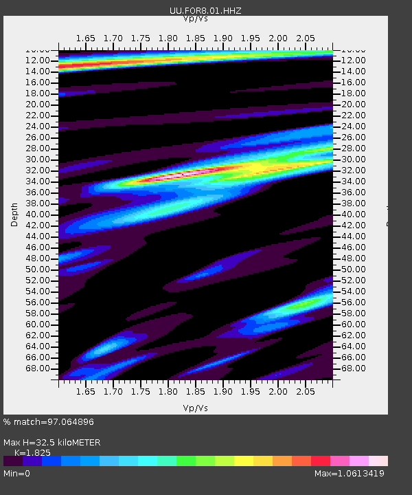
| Estimated Moho Depth: |
32.5 km |
| Estimated Crust Vp/Vs: |
1.83 |
| Assumed Crust Vp: |
6.276 km/s |
| Estimated Crust Vs: |
3.439 km/s |
| Estimated Crust Poisson's Ratio: |
0.29 |
|
| Radial Match: |
97.064896 % |
| Radial Bump: |
382 |
| Transverse Match: |
94.25837 % |
| Transverse Bump: |
400 |
| SOD ConfigId: |
30536071 |
| Insert Time: |
2023-05-24 16:40:37.548 +0000 |
| GWidth: |
2.5 |
| Max Bumps: |
400 |
| Tol: |
0.001 |
|

Signal To Noise
| Channel | StoN | STA | LTA |
| UU:FOR8:01:HHZ:20230510T16:13:08.620006Z | 31.060482 | 3.9714896E-6 | 1.278631E-7 |
| UU:FOR8:01:HHN:20230510T16:13:08.620006Z | 6.277657 | 6.8961816E-7 | 1.098528E-7 |
| UU:FOR8:01:HHE:20230510T16:13:08.620006Z | 4.0633154 | 9.633325E-7 | 2.3708041E-7 |
| Arrivals |
| Ps | 4.4 SECOND |
| PpPs | 14 SECOND |
| PsPs/PpSs | 19 SECOND |


