You are here: Home > Network List > UU - University of Utah Regional Network Stations List
> Station MPU Maple Canyon, UT, USA > Earthquake Result Viewer
MPU Maple Canyon, UT, USA - Earthquake Result Viewer
| Earthquake location: |
Tonga Islands |
| Earthquake latitude/longitude: |
-15.6/-174.6 |
| Earthquake time(UTC): |
2023/05/10 (130) 16:02:00 GMT |
| Earthquake Depth: |
210 km |
| Earthquake Magnitude: |
7.6 mww |
| Earthquake Catalog/Contributor: |
NEIC PDE/us |
|
| Network: |
UU University of Utah Regional Network |
| Station: |
MPU Maple Canyon, UT, USA |
| Lat/Lon: |
40.02 N/111.63 W |
| Elevation: |
1909 m |
|
| Distance: |
80.5 deg |
| Az: |
43.92 deg |
| Baz: |
240.499 deg |
| Ray Param: |
0.047720462 |
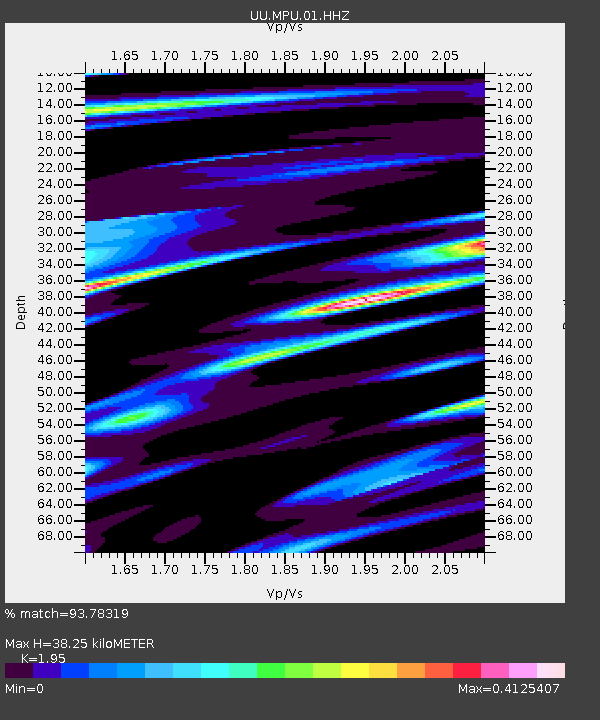
| Estimated Moho Depth: |
38.25 km |
| Estimated Crust Vp/Vs: |
1.95 |
| Assumed Crust Vp: |
6.155 km/s |
| Estimated Crust Vs: |
3.156 km/s |
| Estimated Crust Poisson's Ratio: |
0.32 |
|
| Radial Match: |
93.78319 % |
| Radial Bump: |
400 |
| Transverse Match: |
86.80688 % |
| Transverse Bump: |
400 |
| SOD ConfigId: |
30536071 |
| Insert Time: |
2023-05-24 16:40:53.914 +0000 |
| GWidth: |
2.5 |
| Max Bumps: |
400 |
| Tol: |
0.001 |
|

Signal To Noise
| Channel | StoN | STA | LTA |
| UU:MPU:01:HHZ:20230510T16:13:17.789989Z | 19.165033 | 2.4894412E-6 | 1.2989496E-7 |
| UU:MPU:01:HHN:20230510T16:13:17.789989Z | 2.187932 | 3.0706622E-7 | 1.403454E-7 |
| UU:MPU:01:HHE:20230510T16:13:17.789989Z | 3.608584 | 6.765509E-7 | 1.8748376E-7 |
| Arrivals |
| Ps | 6.0 SECOND |
| PpPs | 18 SECOND |
| PsPs/PpSs | 24 SECOND |


