You are here: Home > Network List > UW - Pacific Northwest Regional Seismic Network Stations List
> Station BLOW BLOW, Detroit Lake, OR, USA > Earthquake Result Viewer
BLOW BLOW, Detroit Lake, OR, USA - Earthquake Result Viewer
| Earthquake location: |
Tonga Islands |
| Earthquake latitude/longitude: |
-15.6/-174.6 |
| Earthquake time(UTC): |
2023/05/10 (130) 16:02:00 GMT |
| Earthquake Depth: |
210 km |
| Earthquake Magnitude: |
7.6 mww |
| Earthquake Catalog/Contributor: |
NEIC PDE/us |
|
| Network: |
UW Pacific Northwest Regional Seismic Network |
| Station: |
BLOW BLOW, Detroit Lake, OR, USA |
| Lat/Lon: |
44.68 N/122.19 W |
| Elevation: |
657 m |
|
| Distance: |
76.6 deg |
| Az: |
35.535 deg |
| Baz: |
231.73 deg |
| Ray Param: |
0.05034856 |
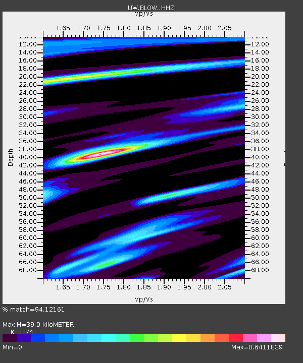
| Estimated Moho Depth: |
39.0 km |
| Estimated Crust Vp/Vs: |
1.74 |
| Assumed Crust Vp: |
6.566 km/s |
| Estimated Crust Vs: |
3.774 km/s |
| Estimated Crust Poisson's Ratio: |
0.25 |
|
| Radial Match: |
94.12161 % |
| Radial Bump: |
400 |
| Transverse Match: |
75.59196 % |
| Transverse Bump: |
400 |
| SOD ConfigId: |
30536071 |
| Insert Time: |
2023-05-24 16:41:22.970 +0000 |
| GWidth: |
2.5 |
| Max Bumps: |
400 |
| Tol: |
0.001 |
|

Signal To Noise
| Channel | StoN | STA | LTA |
| UW:BLOW: :HHZ:20230510T16:12:56.549999Z | 44.965145 | 6.8537533E-6 | 1.5242368E-7 |
| UW:BLOW: :HHN:20230510T16:12:56.549999Z | 10.431476 | 1.3514713E-6 | 1.2955705E-7 |
| UW:BLOW: :HHE:20230510T16:12:56.549999Z | 14.078967 | 1.826776E-6 | 1.2975214E-7 |
| Arrivals |
| Ps | 4.5 SECOND |
| PpPs | 16 SECOND |
| PsPs/PpSs | 20 SECOND |


