You are here: Home > Network List > TA - USArray Transportable Network (new EarthScope stations) Stations List
> Station 128A Castleberry Farm, Seminole, TX, USA > Earthquake Result Viewer
128A Castleberry Farm, Seminole, TX, USA - Earthquake Result Viewer
| Earthquake location: |
Near Coast Of Central Chile |
| Earthquake latitude/longitude: |
-36.2/-73.3 |
| Earthquake time(UTC): |
2010/03/16 (075) 02:21:57 GMT |
| Earthquake Depth: |
18 km |
| Earthquake Magnitude: |
6.0 MB, 6.7 MS, 6.7 MW, 6.6 MW |
| Earthquake Catalog/Contributor: |
WHDF/NEIC |
|
| Network: |
TA USArray Transportable Network (new EarthScope stations) |
| Station: |
128A Castleberry Farm, Seminole, TX, USA |
| Lat/Lon: |
32.62 N/102.49 W |
| Elevation: |
966 m |
|
| Distance: |
73.7 deg |
| Az: |
334.582 deg |
| Baz: |
155.713 deg |
| Ray Param: |
0.05278459 |
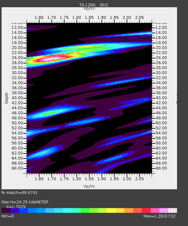
| Estimated Moho Depth: |
24.25 km |
| Estimated Crust Vp/Vs: |
1.70 |
| Assumed Crust Vp: |
6.129 km/s |
| Estimated Crust Vs: |
3.6 km/s |
| Estimated Crust Poisson's Ratio: |
0.24 |
|
| Radial Match: |
89.8741 % |
| Radial Bump: |
400 |
| Transverse Match: |
64.29459 % |
| Transverse Bump: |
400 |
| SOD ConfigId: |
308276 |
| Insert Time: |
2010-06-22 20:20:37.271 +0000 |
| GWidth: |
2.5 |
| Max Bumps: |
400 |
| Tol: |
0.001 |
|

Signal To Noise
| Channel | StoN | STA | LTA |
| TA:128A: :BHZ:20100316T02:32:59.57501Z | 4.3283606 | 7.960396E-7 | 1.8391249E-7 |
| TA:128A: :BHN:20100316T02:32:59.57501Z | 0.84443396 | 2.0190424E-7 | 2.391001E-7 |
| TA:128A: :BHE:20100316T02:32:59.57501Z | 1.1789161 | 2.718272E-7 | 2.3057382E-7 |
| Arrivals |
| Ps | 2.9 SECOND |
| PpPs | 10 SECOND |
| PsPs/PpSs | 13 SECOND |


