You are here: Home > Network List > TA - USArray Transportable Network (new EarthScope stations) Stations List
> Station 229A Bryant Ranch, Stanton, TX, USA > Earthquake Result Viewer
229A Bryant Ranch, Stanton, TX, USA - Earthquake Result Viewer
| Earthquake location: |
Near Coast Of Central Chile |
| Earthquake latitude/longitude: |
-36.2/-73.3 |
| Earthquake time(UTC): |
2010/03/16 (075) 02:21:57 GMT |
| Earthquake Depth: |
18 km |
| Earthquake Magnitude: |
6.0 MB, 6.7 MS, 6.7 MW, 6.6 MW |
| Earthquake Catalog/Contributor: |
WHDF/NEIC |
|
| Network: |
TA USArray Transportable Network (new EarthScope stations) |
| Station: |
229A Bryant Ranch, Stanton, TX, USA |
| Lat/Lon: |
31.97 N/101.81 W |
| Elevation: |
804 m |
|
| Distance: |
72.9 deg |
| Az: |
334.849 deg |
| Baz: |
156.148 deg |
| Ray Param: |
0.053331804 |
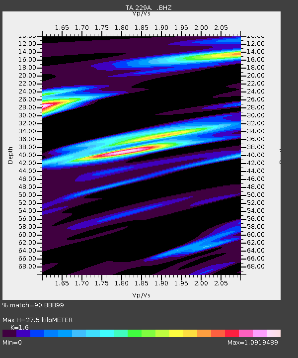
| Estimated Moho Depth: |
27.5 km |
| Estimated Crust Vp/Vs: |
1.60 |
| Assumed Crust Vp: |
6.38 km/s |
| Estimated Crust Vs: |
3.988 km/s |
| Estimated Crust Poisson's Ratio: |
0.18 |
|
| Radial Match: |
90.88899 % |
| Radial Bump: |
400 |
| Transverse Match: |
68.54919 % |
| Transverse Bump: |
400 |
| SOD ConfigId: |
308276 |
| Insert Time: |
2010-06-22 20:20:49.925 +0000 |
| GWidth: |
2.5 |
| Max Bumps: |
400 |
| Tol: |
0.001 |
|

Signal To Noise
| Channel | StoN | STA | LTA |
| TA:229A: :BHZ:20100316T02:32:54.70001Z | 5.6386476 | 8.1193747E-7 | 1.4399507E-7 |
| TA:229A: :BHN:20100316T02:32:54.70001Z | 1.1085662 | 2.782154E-7 | 2.509687E-7 |
| TA:229A: :BHE:20100316T02:32:54.70001Z | 1.7772218 | 3.2742372E-7 | 1.8423346E-7 |
| Arrivals |
| Ps | 2.7 SECOND |
| PpPs | 11 SECOND |
| PsPs/PpSs | 13 SECOND |


