You are here: Home > Network List > UW - Pacific Northwest Regional Seismic Network Stations List
> Station SNAG Snag Peak, Clallam County, WA, USA > Earthquake Result Viewer
SNAG Snag Peak, Clallam County, WA, USA - Earthquake Result Viewer
| Earthquake location: |
Tonga Islands |
| Earthquake latitude/longitude: |
-15.6/-174.6 |
| Earthquake time(UTC): |
2023/05/10 (130) 16:02:00 GMT |
| Earthquake Depth: |
210 km |
| Earthquake Magnitude: |
7.6 mww |
| Earthquake Catalog/Contributor: |
NEIC PDE/us |
|
| Network: |
UW Pacific Northwest Regional Seismic Network |
| Station: |
SNAG Snag Peak, Clallam County, WA, USA |
| Lat/Lon: |
48.21 N/124.52 W |
| Elevation: |
598 m |
|
| Distance: |
77.6 deg |
| Az: |
31.693 deg |
| Baz: |
229.184 deg |
| Ray Param: |
0.04968205 |
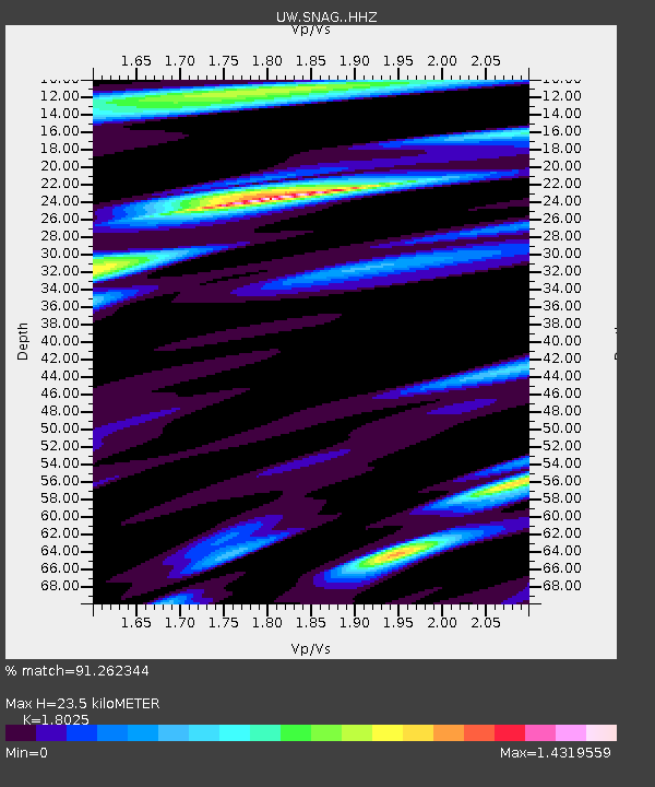
| Estimated Moho Depth: |
23.5 km |
| Estimated Crust Vp/Vs: |
1.80 |
| Assumed Crust Vp: |
6.391 km/s |
| Estimated Crust Vs: |
3.545 km/s |
| Estimated Crust Poisson's Ratio: |
0.28 |
|
| Radial Match: |
91.262344 % |
| Radial Bump: |
400 |
| Transverse Match: |
77.38401 % |
| Transverse Bump: |
400 |
| SOD ConfigId: |
30536071 |
| Insert Time: |
2023-05-24 16:44:29.229 +0000 |
| GWidth: |
2.5 |
| Max Bumps: |
400 |
| Tol: |
0.001 |
|

Signal To Noise
| Channel | StoN | STA | LTA |
| UW:SNAG: :HHZ:20230510T16:13:02.089977Z | 24.3739 | 6.7896995E-6 | 2.7856436E-7 |
| UW:SNAG: :HHN:20230510T16:13:02.089977Z | 3.967915 | 1.3732475E-6 | 3.4608792E-7 |
| UW:SNAG: :HHE:20230510T16:13:02.089977Z | 12.03499 | 2.4739709E-6 | 2.0556485E-7 |
| Arrivals |
| Ps | 3.0 SECOND |
| PpPs | 10 SECOND |
| PsPs/PpSs | 13 SECOND |


