You are here: Home > Network List > UW - Pacific Northwest Regional Seismic Network Stations List
> Station TBLMT Table Mt, Ellensburg, WA, USA > Earthquake Result Viewer
TBLMT Table Mt, Ellensburg, WA, USA - Earthquake Result Viewer
| Earthquake location: |
Tonga Islands |
| Earthquake latitude/longitude: |
-15.6/-174.6 |
| Earthquake time(UTC): |
2023/05/10 (130) 16:02:00 GMT |
| Earthquake Depth: |
210 km |
| Earthquake Magnitude: |
7.6 mww |
| Earthquake Catalog/Contributor: |
NEIC PDE/us |
|
| Network: |
UW Pacific Northwest Regional Seismic Network |
| Station: |
TBLMT Table Mt, Ellensburg, WA, USA |
| Lat/Lon: |
47.17 N/120.60 W |
| Elevation: |
1088 m |
|
| Distance: |
79.0 deg |
| Az: |
34.219 deg |
| Baz: |
232.589 deg |
| Ray Param: |
0.04873219 |
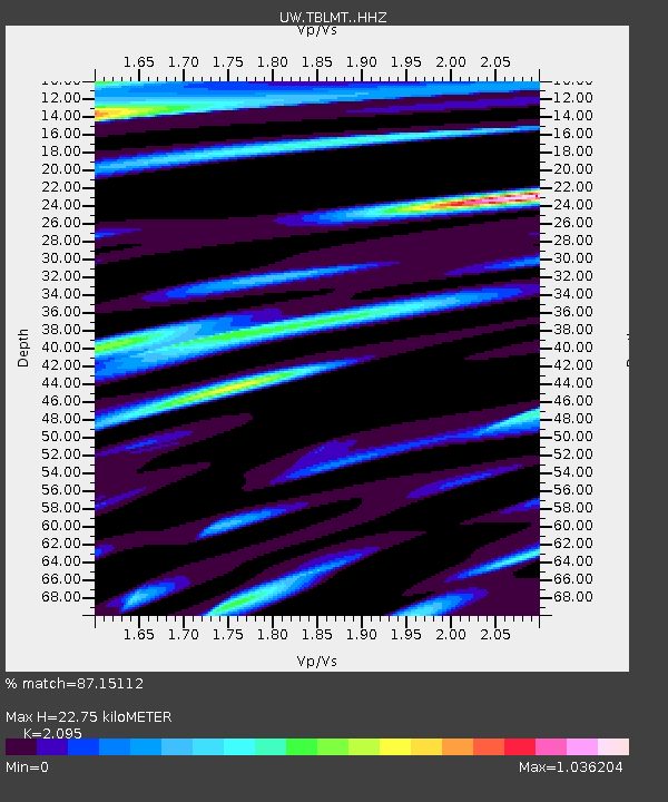
| Estimated Moho Depth: |
22.75 km |
| Estimated Crust Vp/Vs: |
2.10 |
| Assumed Crust Vp: |
6.597 km/s |
| Estimated Crust Vs: |
3.149 km/s |
| Estimated Crust Poisson's Ratio: |
0.35 |
|
| Radial Match: |
87.15112 % |
| Radial Bump: |
400 |
| Transverse Match: |
77.791916 % |
| Transverse Bump: |
400 |
| SOD ConfigId: |
30536071 |
| Insert Time: |
2023-05-24 16:44:38.989 +0000 |
| GWidth: |
2.5 |
| Max Bumps: |
400 |
| Tol: |
0.001 |
|

Signal To Noise
| Channel | StoN | STA | LTA |
| UW:TBLMT: :HHZ:20230510T16:13:09.750011Z | 52.51677 | 8.207623E-6 | 1.5628575E-7 |
| UW:TBLMT: :HHN:20230510T16:13:09.750011Z | 8.246873 | 1.6805104E-6 | 2.0377547E-7 |
| UW:TBLMT: :HHE:20230510T16:13:09.750011Z | 4.0533943 | 1.692196E-6 | 4.1747626E-7 |
| Arrivals |
| Ps | 3.9 SECOND |
| PpPs | 10 SECOND |
| PsPs/PpSs | 14 SECOND |


