You are here: Home > Network List > IW - Intermountain West Stations List
> Station MOOW Moose Ponds, Wyoming, USA > Earthquake Result Viewer
MOOW Moose Ponds, Wyoming, USA - Earthquake Result Viewer
*The percent match for this event was below the threshold and hence no stack was calculated.
| Earthquake location: |
Mariana Islands Region |
| Earthquake latitude/longitude: |
17.4/147.9 |
| Earthquake time(UTC): |
2018/10/26 (299) 09:05:39 GMT |
| Earthquake Depth: |
10 km |
| Earthquake Magnitude: |
5.7 mww |
| Earthquake Catalog/Contributor: |
NEIC PDE/us |
|
| Network: |
IW Intermountain West |
| Station: |
MOOW Moose Ponds, Wyoming, USA |
| Lat/Lon: |
43.75 N/110.74 W |
| Elevation: |
2128 m |
|
| Distance: |
86.1 deg |
| Az: |
45.406 deg |
| Baz: |
290.228 deg |
| Ray Param: |
$rayparam |
*The percent match for this event was below the threshold and hence was not used in the summary stack. |
|
| Radial Match: |
71.26071 % |
| Radial Bump: |
400 |
| Transverse Match: |
47.470554 % |
| Transverse Bump: |
400 |
| SOD ConfigId: |
3103472 |
| Insert Time: |
2018-11-09 17:10:40.406 +0000 |
| GWidth: |
2.5 |
| Max Bumps: |
400 |
| Tol: |
0.001 |
|
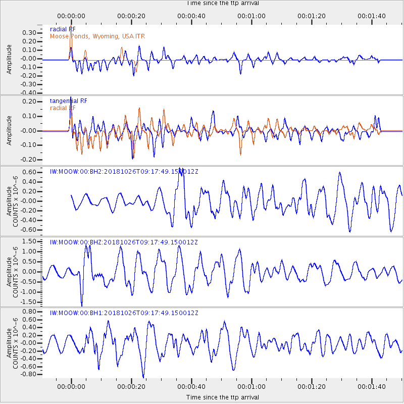
Signal To Noise
| Channel | StoN | STA | LTA |
| IW:MOOW:00:BHZ:20181026T09:17:49.150012Z | 3.9113882 | 6.5294483E-7 | 1.6693431E-7 |
| IW:MOOW:00:BH1:20181026T09:17:49.150012Z | 1.3270196 | 1.6340803E-7 | 1.2313913E-7 |
| IW:MOOW:00:BH2:20181026T09:17:49.150012Z | 2.8313043 | 2.7045968E-7 | 9.552476E-8 |
| Arrivals |
| Ps | |
| PpPs | |
| PsPs/PpSs | |


