You are here: Home > Network List > TA - USArray Transportable Network (new EarthScope stations) Stations List
> Station Y32A R-V Farms, Vernon, TX, USA > Earthquake Result Viewer
Y32A R-V Farms, Vernon, TX, USA - Earthquake Result Viewer
| Earthquake location: |
Near Coast Of Central Chile |
| Earthquake latitude/longitude: |
-36.2/-73.3 |
| Earthquake time(UTC): |
2010/03/16 (075) 02:21:57 GMT |
| Earthquake Depth: |
18 km |
| Earthquake Magnitude: |
6.0 MB, 6.7 MS, 6.7 MW, 6.6 MW |
| Earthquake Catalog/Contributor: |
WHDF/NEIC |
|
| Network: |
TA USArray Transportable Network (new EarthScope stations) |
| Station: |
Y32A R-V Farms, Vernon, TX, USA |
| Lat/Lon: |
34.00 N/99.44 W |
| Elevation: |
412 m |
|
| Distance: |
74.0 deg |
| Az: |
337.584 deg |
| Baz: |
158.211 deg |
| Ray Param: |
0.05260233 |
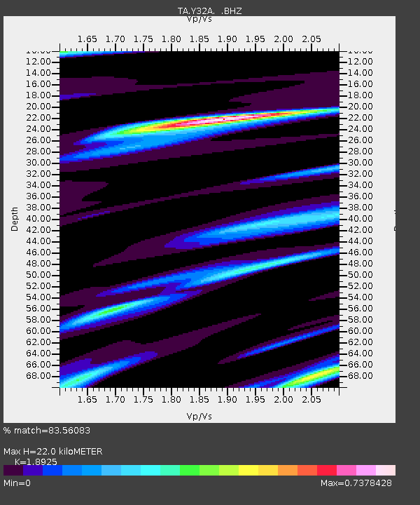
| Estimated Moho Depth: |
22.0 km |
| Estimated Crust Vp/Vs: |
1.89 |
| Assumed Crust Vp: |
6.315 km/s |
| Estimated Crust Vs: |
3.337 km/s |
| Estimated Crust Poisson's Ratio: |
0.31 |
|
| Radial Match: |
83.56083 % |
| Radial Bump: |
396 |
| Transverse Match: |
76.469925 % |
| Transverse Bump: |
400 |
| SOD ConfigId: |
308276 |
| Insert Time: |
2010-06-22 20:23:43.396 +0000 |
| GWidth: |
2.5 |
| Max Bumps: |
400 |
| Tol: |
0.001 |
|
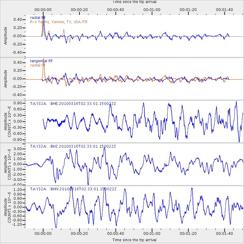
Signal To Noise
| Channel | StoN | STA | LTA |
| TA:Y32A: :BHZ:20100316T02:33:01.150022Z | 4.239351 | 8.263877E-7 | 1.9493261E-7 |
| TA:Y32A: :BHN:20100316T02:33:01.150022Z | 1.877926 | 3.748392E-7 | 1.9960275E-7 |
| TA:Y32A: :BHE:20100316T02:33:01.150022Z | 1.1666214 | 2.2705512E-7 | 1.9462622E-7 |
| Arrivals |
| Ps | 3.2 SECOND |
| PpPs | 9.8 SECOND |
| PsPs/PpSs | 13 SECOND |


