You are here: Home > Network List > ND - New CaleDonia Broadband Seismic Network Stations List
> Station KOUNC Koumac, New Caledonia > Earthquake Result Viewer
KOUNC Koumac, New Caledonia - Earthquake Result Viewer

| Earthquake location: |
Mariana Islands Region |
| Earthquake latitude/longitude: |
17.4/147.9 |
| Earthquake time(UTC): |
2018/10/26 (299) 09:05:39 GMT |
| Earthquake Depth: |
10 km |
| Earthquake Magnitude: |
5.7 mww |
| Earthquake Catalog/Contributor: |
NEIC PDE/us |
|
| Network: |
ND New CaleDonia Broadband Seismic Network |
| Station: |
KOUNC Koumac, New Caledonia |
| Lat/Lon: |
20.55 S/164.29 E |
| Elevation: |
88 m |
|
| Distance: |
41.0 deg |
| Az: |
156.195 deg |
| Baz: |
335.714 deg |
| Ray Param: |
0.07407227 |
| Estimated Moho Depth: |
19.5 km |
| Estimated Crust Vp/Vs: |
1.94 |
| Assumed Crust Vp: |
5.14 km/s |
| Estimated Crust Vs: |
2.646 km/s |
| Estimated Crust Poisson's Ratio: |
0.32 |
|
| Radial Match: |
80.39398 % |
| Radial Bump: |
400 |
| Transverse Match: |
79.76072 % |
| Transverse Bump: |
400 |
| SOD ConfigId: |
3103472 |
| Insert Time: |
2018-11-09 17:10:55.166 +0000 |
| GWidth: |
2.5 |
| Max Bumps: |
400 |
| Tol: |
0.001 |
|
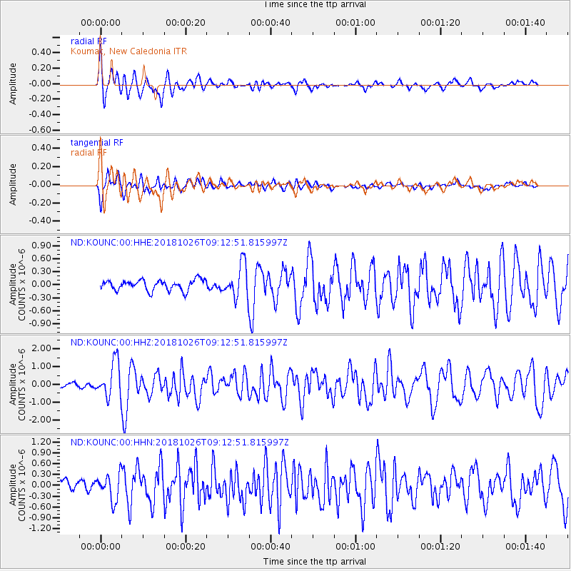
Signal To Noise
| Channel | StoN | STA | LTA |
| ND:KOUNC:00:HHZ:20181026T09:12:51.815997Z | 5.7181764 | 1.0327585E-6 | 1.8060977E-7 |
| ND:KOUNC:00:HHN:20181026T09:12:51.815997Z | 2.5925221 | 3.6844898E-7 | 1.421199E-7 |
| ND:KOUNC:00:HHE:20181026T09:12:51.815997Z | 3.2618854 | 3.9428429E-7 | 1.208762E-7 |
| Arrivals |
| Ps | 3.7 SECOND |
| PpPs | 11 SECOND |
| PsPs/PpSs | 14 SECOND |


