You are here: Home > Network List > TA - USArray Transportable Network (new EarthScope stations) Stations List
> Station S30A Montezuma, KS, USA > Earthquake Result Viewer
S30A Montezuma, KS, USA - Earthquake Result Viewer
| Earthquake location: |
Near Coast Of Central Chile |
| Earthquake latitude/longitude: |
-36.2/-73.3 |
| Earthquake time(UTC): |
2010/03/16 (075) 02:21:57 GMT |
| Earthquake Depth: |
18 km |
| Earthquake Magnitude: |
6.0 MB, 6.7 MS, 6.7 MW, 6.6 MW |
| Earthquake Catalog/Contributor: |
WHDF/NEIC |
|
| Network: |
TA USArray Transportable Network (new EarthScope stations) |
| Station: |
S30A Montezuma, KS, USA |
| Lat/Lon: |
37.64 N/100.46 W |
| Elevation: |
853 m |
|
| Distance: |
77.7 deg |
| Az: |
338.193 deg |
| Baz: |
157.764 deg |
| Ray Param: |
0.050135657 |
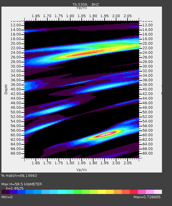
| Estimated Moho Depth: |
59.5 km |
| Estimated Crust Vp/Vs: |
1.95 |
| Assumed Crust Vp: |
6.483 km/s |
| Estimated Crust Vs: |
3.32 km/s |
| Estimated Crust Poisson's Ratio: |
0.32 |
|
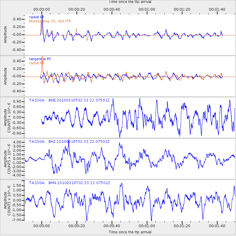
| Radial Match: |
86.14863 % |
| Radial Bump: |
400 |
| Transverse Match: |
76.73093 % |
| Transverse Bump: |
400 |
| SOD ConfigId: |
308276 |
| Insert Time: |
2010-06-22 20:25:11.829 +0000 |
| GWidth: |
2.5 |
| Max Bumps: |
400 |
| Tol: |
0.001 |
|
Signal To Noise
| Channel | StoN | STA | LTA |
| TA:S30A: :BHZ:20100316T02:33:22.07501Z | 2.8395615 | 8.6057236E-7 | 3.0306524E-7 |
| TA:S30A: :BHN:20100316T02:33:22.07501Z | 2.1221607 | 5.5800274E-7 | 2.6294086E-7 |
| TA:S30A: :BHE:20100316T02:33:22.07501Z | 0.8863025 | 2.3332012E-7 | 2.632511E-7 |
| Arrivals |
| Ps | 9.0 SECOND |
| PpPs | 26 SECOND |
| PsPs/PpSs | 35 SECOND |


