You are here: Home > Network List > TA - USArray Transportable Network (new EarthScope stations) Stations List
> Station Q29A Oakley, KS, USA > Earthquake Result Viewer
Q29A Oakley, KS, USA - Earthquake Result Viewer
| Earthquake location: |
Near Coast Of Central Chile |
| Earthquake latitude/longitude: |
-36.2/-73.3 |
| Earthquake time(UTC): |
2010/03/16 (075) 02:21:57 GMT |
| Earthquake Depth: |
18 km |
| Earthquake Magnitude: |
6.0 MB, 6.7 MS, 6.7 MW, 6.6 MW |
| Earthquake Catalog/Contributor: |
WHDF/NEIC |
|
| Network: |
TA USArray Transportable Network (new EarthScope stations) |
| Station: |
Q29A Oakley, KS, USA |
| Lat/Lon: |
38.89 N/100.98 W |
| Elevation: |
895 m |
|
| Distance: |
79.0 deg |
| Az: |
338.295 deg |
| Baz: |
157.467 deg |
| Ray Param: |
0.049246833 |
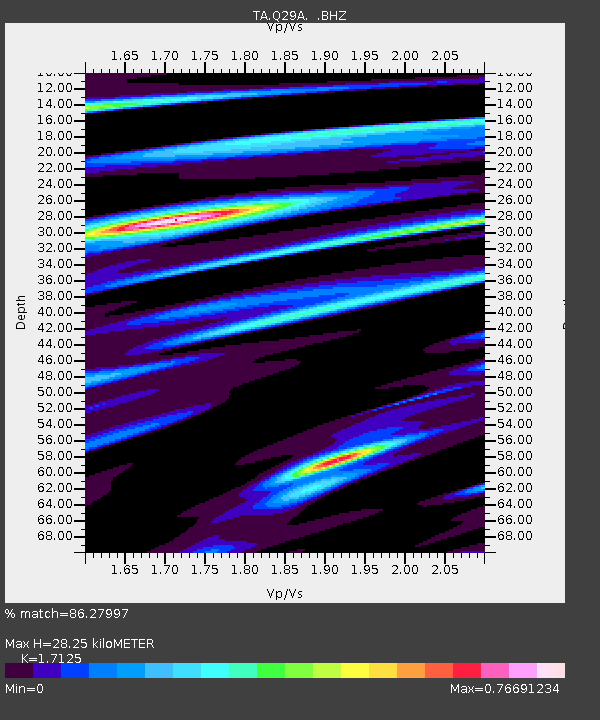
| Estimated Moho Depth: |
28.25 km |
| Estimated Crust Vp/Vs: |
1.71 |
| Assumed Crust Vp: |
6.483 km/s |
| Estimated Crust Vs: |
3.785 km/s |
| Estimated Crust Poisson's Ratio: |
0.24 |
|
| Radial Match: |
86.27997 % |
| Radial Bump: |
400 |
| Transverse Match: |
65.92011 % |
| Transverse Bump: |
400 |
| SOD ConfigId: |
308276 |
| Insert Time: |
2010-06-22 20:26:00.407 +0000 |
| GWidth: |
2.5 |
| Max Bumps: |
400 |
| Tol: |
0.001 |
|

Signal To Noise
| Channel | StoN | STA | LTA |
| TA:Q29A: :BHZ:20100316T02:33:29.299985Z | 5.746721 | 8.4267157E-7 | 1.466352E-7 |
| TA:Q29A: :BHN:20100316T02:33:29.299985Z | 1.6081418 | 3.8693767E-7 | 2.4061168E-7 |
| TA:Q29A: :BHE:20100316T02:33:29.299985Z | 1.6893504 | 2.3875742E-7 | 1.413309E-7 |
| Arrivals |
| Ps | 3.2 SECOND |
| PpPs | 11 SECOND |
| PsPs/PpSs | 15 SECOND |


