You are here: Home > Network List > TA - USArray Transportable Network (new EarthScope stations) Stations List
> Station TOLK Toolik Lake Research Station, AK, USA > Earthquake Result Viewer
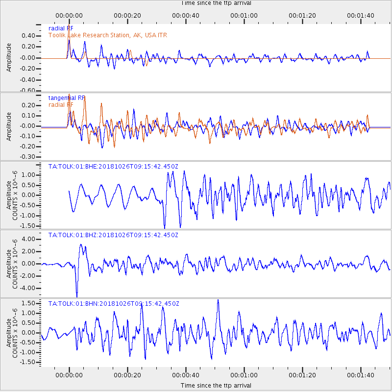
TOLK Toolik Lake Research Station, AK, USA - Earthquake Result Viewer
*The percent match for this event was below the threshold and hence no stack was calculated.
| Earthquake location: |
Mariana Islands Region |
| Earthquake latitude/longitude: |
17.4/147.9 |
| Earthquake time(UTC): |
2018/10/26 (299) 09:05:39 GMT |
| Earthquake Depth: |
10 km |
| Earthquake Magnitude: |
5.7 mww |
| Earthquake Catalog/Contributor: |
NEIC PDE/us |
|
| Network: |
TA USArray Transportable Network (new EarthScope stations) |
| Station: |
TOLK Toolik Lake Research Station, AK, USA |
| Lat/Lon: |
68.64 N/149.57 W |
| Elevation: |
760 m |
|
| Distance: |
64.1 deg |
| Az: |
21.194 deg |
| Baz: |
250.456 deg |
| Ray Param: |
$rayparam |
*The percent match for this event was below the threshold and hence was not used in the summary stack. |
|
| Radial Match: |
76.61078 % |
| Radial Bump: |
400 |
| Transverse Match: |
65.253746 % |
| Transverse Bump: |
400 |
| SOD ConfigId: |
3103472 |
| Insert Time: |
2018-11-09 17:11:33.472 +0000 |
| GWidth: |
2.5 |
| Max Bumps: |
400 |
| Tol: |
0.001 |
|
Signal To Noise
| Channel | StoN | STA | LTA |
| TA:TOLK:01:BHZ:20181026T09:15:42.450Z | 4.5671825 | 2.0774849E-6 | 4.548723E-7 |
| TA:TOLK:01:BHN:20181026T09:15:42.450Z | 0.9621754 | 2.9419286E-7 | 3.0575802E-7 |
| TA:TOLK:01:BHE:20181026T09:15:42.450Z | 1.8426696 | 6.6551115E-7 | 3.6116683E-7 |
| Arrivals |
| Ps | |
| PpPs | |
| PsPs/PpSs | |


