You are here: Home > Network List > TA - USArray Transportable Network (new EarthScope stations) Stations List
> Station P30A Selden, KS, USA > Earthquake Result Viewer
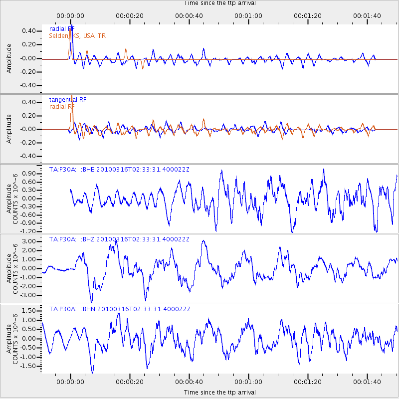
P30A Selden, KS, USA - Earthquake Result Viewer
*The percent match for this event was below the threshold and hence no stack was calculated.
| Earthquake location: |
Near Coast Of Central Chile |
| Earthquake latitude/longitude: |
-36.2/-73.3 |
| Earthquake time(UTC): |
2010/03/16 (075) 02:21:57 GMT |
| Earthquake Depth: |
18 km |
| Earthquake Magnitude: |
6.0 MB, 6.7 MS, 6.7 MW, 6.6 MW |
| Earthquake Catalog/Contributor: |
WHDF/NEIC |
|
| Network: |
TA USArray Transportable Network (new EarthScope stations) |
| Station: |
P30A Selden, KS, USA |
| Lat/Lon: |
39.54 N/100.25 W |
| Elevation: |
788 m |
|
| Distance: |
79.4 deg |
| Az: |
339.083 deg |
| Baz: |
158.075 deg |
| Ray Param: |
$rayparam |
*The percent match for this event was below the threshold and hence was not used in the summary stack. |
|
| Radial Match: |
69.164375 % |
| Radial Bump: |
400 |
| Transverse Match: |
55.45173 % |
| Transverse Bump: |
400 |
| SOD ConfigId: |
308276 |
| Insert Time: |
2010-06-22 20:26:24.722 +0000 |
| GWidth: |
2.5 |
| Max Bumps: |
400 |
| Tol: |
0.001 |
|
Signal To Noise
| Channel | StoN | STA | LTA |
| TA:P30A: :BHZ:20100316T02:33:31.400022Z | 4.0751786 | 9.46354E-7 | 2.3222394E-7 |
| TA:P30A: :BHN:20100316T02:33:31.400022Z | 0.6974484 | 4.0481424E-7 | 5.8042184E-7 |
| TA:P30A: :BHE:20100316T02:33:31.400022Z | 2.2329829 | 4.3604166E-7 | 1.9527316E-7 |
| Arrivals |
| Ps | |
| PpPs | |
| PsPs/PpSs | |


