You are here: Home > Network List > IW - Intermountain West Stations List
> Station PLID Pearl Lake, Idaho, USA > Earthquake Result Viewer
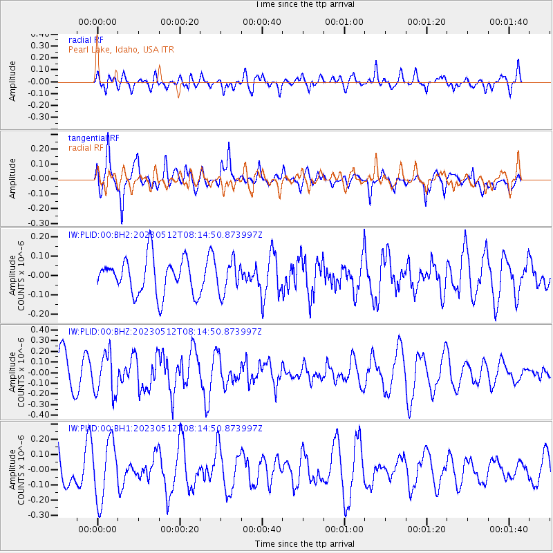
PLID Pearl Lake, Idaho, USA - Earthquake Result Viewer
*The percent match for this event was below the threshold and hence no stack was calculated.
| Earthquake location: |
South Of Mariana Islands |
| Earthquake latitude/longitude: |
12.4/144.2 |
| Earthquake time(UTC): |
2023/05/12 (132) 08:02:31 GMT |
| Earthquake Depth: |
10 km |
| Earthquake Magnitude: |
5.5 Mww |
| Earthquake Catalog/Contributor: |
NEIC PDE/us |
|
| Network: |
IW Intermountain West |
| Station: |
PLID Pearl Lake, Idaho, USA |
| Lat/Lon: |
45.09 N/116.00 W |
| Elevation: |
2164 m |
|
| Distance: |
88.1 deg |
| Az: |
44.298 deg |
| Baz: |
285.604 deg |
| Ray Param: |
$rayparam |
*The percent match for this event was below the threshold and hence was not used in the summary stack. |
|
| Radial Match: |
49.114998 % |
| Radial Bump: |
400 |
| Transverse Match: |
74.44273 % |
| Transverse Bump: |
400 |
| SOD ConfigId: |
30536071 |
| Insert Time: |
2023-05-26 08:14:54.495 +0000 |
| GWidth: |
2.5 |
| Max Bumps: |
400 |
| Tol: |
0.001 |
|
Signal To Noise
| Channel | StoN | STA | LTA |
| IW:PLID:00:BHZ:20230512T08:14:50.873997Z | 1.1761279 | 1.9668364E-7 | 1.672298E-7 |
| IW:PLID:00:BH1:20230512T08:14:50.873997Z | 1.5986263 | 1.9844252E-7 | 1.2413315E-7 |
| IW:PLID:00:BH2:20230512T08:14:50.873997Z | 0.88979435 | 8.2045965E-8 | 9.2207785E-8 |
| Arrivals |
| Ps | |
| PpPs | |
| PsPs/PpSs | |


