You are here: Home > Network List > US - United States National Seismic Network Stations List
> Station EGMT Eagleton, Montana, USA > Earthquake Result Viewer
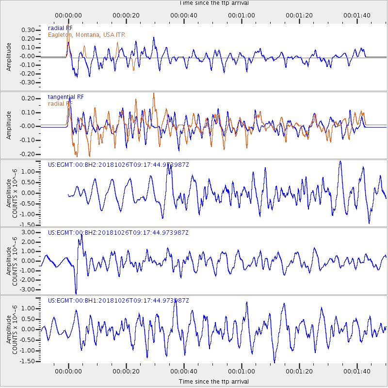
EGMT Eagleton, Montana, USA - Earthquake Result Viewer
*The percent match for this event was below the threshold and hence no stack was calculated.
| Earthquake location: |
Mariana Islands Region |
| Earthquake latitude/longitude: |
17.4/147.9 |
| Earthquake time(UTC): |
2018/10/26 (299) 09:05:39 GMT |
| Earthquake Depth: |
10 km |
| Earthquake Magnitude: |
5.7 mww |
| Earthquake Catalog/Contributor: |
NEIC PDE/us |
|
| Network: |
US United States National Seismic Network |
| Station: |
EGMT Eagleton, Montana, USA |
| Lat/Lon: |
48.02 N/109.75 W |
| Elevation: |
1055 m |
|
| Distance: |
85.3 deg |
| Az: |
41.145 deg |
| Baz: |
290.616 deg |
| Ray Param: |
$rayparam |
*The percent match for this event was below the threshold and hence was not used in the summary stack. |
|
| Radial Match: |
69.748024 % |
| Radial Bump: |
400 |
| Transverse Match: |
58.20638 % |
| Transverse Bump: |
400 |
| SOD ConfigId: |
3103472 |
| Insert Time: |
2018-11-09 17:12:29.830 +0000 |
| GWidth: |
2.5 |
| Max Bumps: |
400 |
| Tol: |
0.001 |
|
Signal To Noise
| Channel | StoN | STA | LTA |
| US:EGMT:00:BHZ:20181026T09:17:44.973987Z | 4.536227 | 1.6081283E-6 | 3.5450788E-7 |
| US:EGMT:00:BH1:20181026T09:17:44.973987Z | 2.3965096 | 5.2050365E-7 | 2.171924E-7 |
| US:EGMT:00:BH2:20181026T09:17:44.973987Z | 1.7568474 | 7.018411E-7 | 3.9948893E-7 |
| Arrivals |
| Ps | |
| PpPs | |
| PsPs/PpSs | |


